Beijing Ecological Infrastructure
2010-06-28
来源:The Minimum Ecological Security Pattern for Beijing’s Urban Sprawl: Basic Ecosystems Services and their Security Patterns, City Planning Review, 2010(2):19-24
分享
Project Location: Beijing, China
Project Type: Regional landscape, Green infrastructure, Ecological planning
Client: Beijing Land Resource Bureau, China
Planning and research team: Turenscape and Peking University Graduate School of Landscape Architecture
Published at: YU Kongjian; WANG Sisi; Qiao Qing; Li Dihua, 2010, The Minimum Ecological Security Pattern for Beijing’s Urban Sprawl: Basic Ecosystems Services and their Security Patterns, City Planning Review, (2):19-24;
YU Kongjian,WANG Si-Si,LI Di-Hua, LI Chun-Bo, 2009, The Function of Ecological Security Patterns as an Urban Growth Framework in Beijing. Acta Ecologica Sinia:(29)3:1180-1204
Project Statement:
Using GIS models, strategic landscape elements and patterns for storm water management and flood control, biodiversity conservation, cultural heritage protection and recreational use are integrated into a comprehensive EI, which is then used to determine future urban growth patterns. This project demonstrates how landscape planning can play a leading role in urban development through applying ecological infrastructure (EI) as a tool for smart growth and smart conservation.
Project Narrative:
1 The Background and Main Issues
Beijing, the capital of China, is situated in the North China Plain, with a total area of 16,410 km2. Due to its rapid urbanization during the last 30 years, its population has doubled from 8.7 million in 1978 to about 17 million in 2009, and its built-up area has expanded 7 folds and is still expanding. The notorious “scrambled egg” pattern is the evidence of the speed and magnitude of the urban spread, and the failure of the conventional planning approach, which tries to control the urban growth using arbitrary green belts. As a payment for the uncontrolled spread of the growing city, the local and regional natural systems and cultural heritages are damaged significantly, the city is now facing multiple challenges, including: (1)Shortage of water;(2)Increased vulnerability to geological disasters;(3) Loss of Habitats and Biodiversity; (4) Loss of Integrity and Authenticity of Cultural Landscape;(5) Decrease of Accessibility of landscape for recreational use; (6) Dramatic loss of land fertility for agricultural use.
Although greenbelts and green wedges have been planned to stop urban sprawl and keep good landscape structure, it has somehow failed. Greenbelts encircling Beijing city were planned artificially and lack of the intrinsic relationship between the green elements and the environmental earth system. It also lacked integration of various functions, and are vulnerable to land use change and have already been fragmented by large settlement areas. New and more effective tools have to be developed to address a wiser and sustainable development of the limited land.
The solution is Ecological Infrastructure.
2 The Project’s goals and objectives
In addressing the above challenges, the planners take land as a living system, and develop an ecological infrastructure (EI), to guide and frame the urban sprawl. The EI is defined as the structural landscape network that is composed of the critical landscape elements and spatial patterns that are of strategic significance in safeguarding the integrity and identity of the natural and cultural landscapes and securing sustainable ecosystem services.
By using minimum space, the EI will safeguard the following critical eco-services including:
(1) To retain the storm water as much as possible to recharge the aquifer, while protecting the city from the threat of floods and waterlog;
(2) To avoid the risk of geological disasters;
(3) To protecting critical native habitats, and building an effective biological framework to maximally safeguard the biodiversity;
(4) To protect and regaining the integrity and authenticity of the cultural landscape;
(5) To increase the accessibility of the landscape for recreational uses;
(6) To maximally protect fertile land from being swallowed by the urban development while not impeding the urban growth
The final objective is Smart Protection and Smart Growth.
3 Methodology
3. 1 Targeted Critical Processes
Critical processes of three categories are targeted to be safeguarded:
(1)The Abiotic Processes: the main focus is flood control, storm water management and surface resource protection, geological disaster prevention.
(2) Biotic Processes: native species and biodiversity conservation.
(3) Cultural Processes: including cultural heritage protection and recreational need.
3. 2 Defining Landscape Security Patterns
Landscape Security Patterns (SPs) are critical elements, spatial positions and spatial relationships that are strategically important in safeguarding the concerned processes of the landscape.
Models including suitability analysis, minimum cost distance and surface models were used in the identification of security patterns for the individual processes.
(1) SPs for water management are composed of: existing surface water features and buffer zones around them, areas most suitable for retaining raining water and recharging the aquifer. Both historical flood data and the simulated flood risk rating are used to calculate the floodable area.
(2)SPs to avoid geological disasters are composed of: the source elements such as debris flow, landslide, collapse, mining subsidence, land subsidence, ground fissure and soil erosion, and the buffer zones around them.
(3)SPs for biodiversity conservation are developed following the focal species approach in biodiversity conservation. Three focal species are selected to represent the biodiversity in Beijing area. SPs for each of the focal species are defined by integrating both suitability analysis and spatial pattern analysis. The overall SPs for biodiversity conservation are developed by combining all the SPs for individual focal species. The combined SPs are composed of habitat patches, corridors and strategic points (key points) that are strategically important for keeping the integrity of the biological network.
(4)SPs for cultural heritage preservation are composed of both existing and potential heritage sites and linear features. Both designated heritage sites and vernacular landscapes that give identity to Beijing are identified as the sources for protection. Historical paths are identified based on written and graphic data. Suitability for building heritage corridors is calculated based on land cover and distances from the heritage sites and linear features. A network of heritage corridors is then planned for preservation, education and recreation purposes.
(5) SPs for recreation are defined according to both existing and potential recreational resources of natural and cultural landscapes, as well as their accessibility and potential linkages: Urban parks, national and regional parks, cultural heritage sites, vernacular landscapes, potential natural and cultural sites are identified as the source of recreation process. Suitability for building recreation corridors are calculated based on land cover and distances from the recreation resources and linear features. The categories of SPs for recreation are classified according to the recreational values of these sites, their accessibility and potential linkages. A regional network for recreation is planned based on the identified SPs.
Three security levels - low, medium and high - are used to define the quality of the security patterns in safeguarding each of the targeted processes.
3.3 Defining comprehensive Ecological Infrastructure by integrating SPs of individual processes
Landscape Security Patterns (SPs) that safeguard the individual processes are integrated into the overall comprehensive Ecological Infrastructure (EI). Using overlaying technique to integrate the SPs for individual processes, alternatives of regional ecological infrastructure are developed at various quality levels:
(1)EI at the low (minimum) quality: 47% of the total land, including 24% of the most fertile land is protected. The integrity of the critical ecological processes will be protected at the minimum level, providing essential ecosystems services. The regional environment will be stable for the time being.
(2) EI at a medium (satisfactory) quality. 70% of the total land, including 45% of the most fertile land is protected. The integrity of the critical ecological processes will be protected at the satisfying level, providing good enough and sustainable ecosystems services. The regional environment will be regenerated gradually.
(3) EI at a high (ideal) quality. 85% of the total land, including100% of the most fertile land is protected for organic agriculture. The integrity of the critical ecological processes will be protected at the ideal level, providing more than good enough ecosystems services. The regional environment will be regenerated dramatically.
Detailed guidelines have been developed for the protection and management for components of EI at various scales. All three alternatives of EI will be used to guide and frame regional urban growth to develop multiple scenarios of urban growth pattern.
3.4 Scenarios of urban growth pattern based on ecological infrastructure
Using the three EI alternatives as framing structure, scenarios of regional urban growth patterns were simulated using GIS:
(1) Scenario-1, The “scrambled egg”: Urban Growth without EI.
(2) Scenario-2, Green Infrastructure Within the City: Urban growth based on Minimum EI.
(3) Scenario-3, City on the Green Infrastructure: Urban Growth Based on Satisfying EI.
(4) Scenario-4, Garden suburban: Urban Growth based on Ideal EI.
Comparative evaluations are made for all four urban growth scenarios based on their impacts on ecological processes, cultural process and economic processes, and their capacity in solving the 6 challenging problems identified at the introduction of this document. At Scenario-3: City on the Green Infrastructure can best fulfill goals of both conservation and development, and meet the requirement of all competing land use requirements. This is a smarter scenario, which means the limited land can be used, through a better configuration, more efficiently for both conservation and urban development.
4 The implementation of EI and urban growth scenarios analysis
The research result provided scientific basis for land use planning and urban development planning in Beijing across scales. Strategies and guidelines following the EI planning have been applied in urban design and site planning. In this submission, one example of urban design based on EI is presented as an illustration. It is anticipated to play a positive and significant role in the land resources planning and urban growth management in Beijing.
The results have shown that the urban growth model based on EI builds a bridge between Landscape Urbanism, the disciplines of Ecology and especially Landscape Ecology, the notion of Natural Capital and ecosystems services, and Sustainable Development. It is a bridge between smart growth and smart conservation.
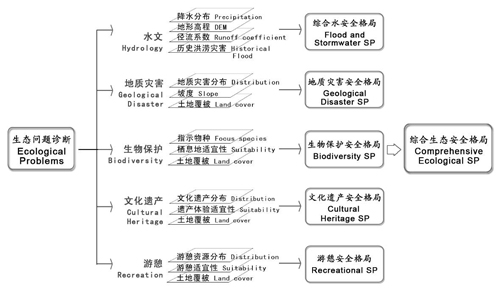
Fig.1 Research Framework of Ecological Security Pattern(Landscape Security Pattern) in Beijing
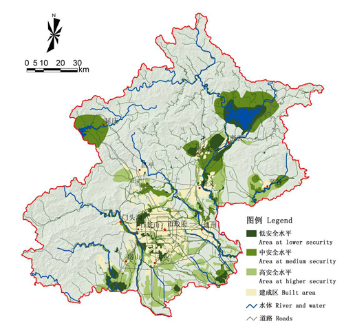
Fig.2 Water Security Pattern
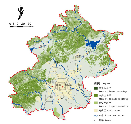
Fig.3 Geological Disaster Security Pattern
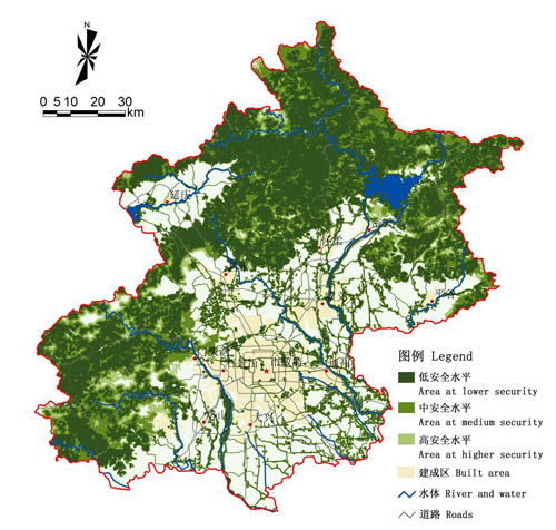
Fig.4 Security Pattern for Biodiversity
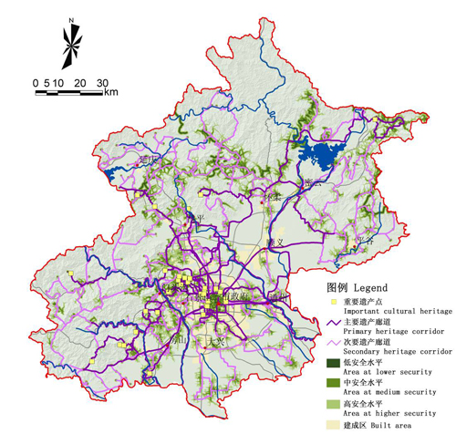
Fig.5 Security Pattern for cultural heritage
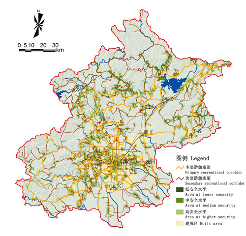
Fig.6 Security Pattern for Recreation
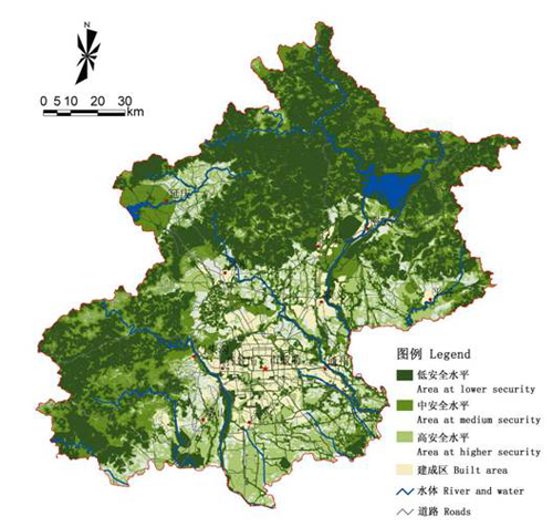
Fig.7 Comprehensive Ecological Security Pattern in Beijing
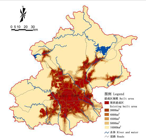
Fig.8 Urban Growth Pattern without Ecological SP
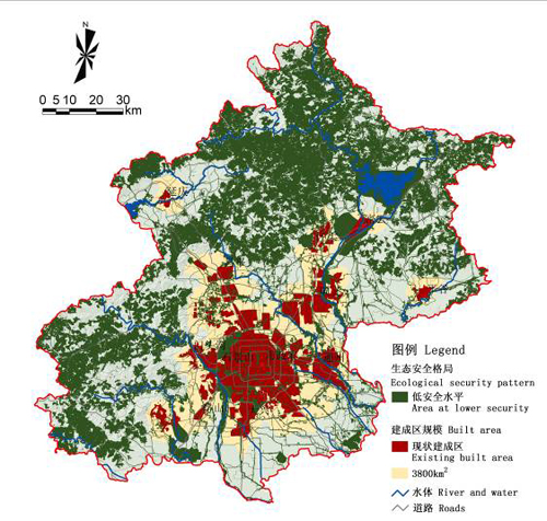
Fig.9 Urban Growth Pattern Based on Minimum Ecological SP
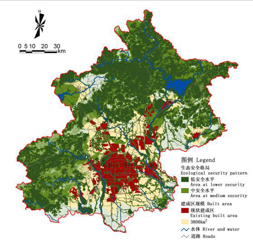
Fig.10 Urban Growth Pattern Based on Satisfying Ecological SP
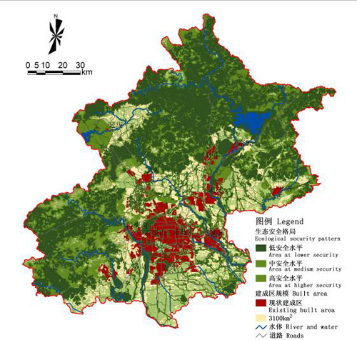
Fig.11 Urban Growth Pattern Based on Ideal Ecological SP
