基于生态系统服务的黄河滩区生态修复模式探索——以郑州黄河滩地公园规划设计为例
- 摘要:
- 黄河流域是中国重要的生态屏障和经济带,黄河生态系统是一个有机整体,下游的黄河滩地对流域生态系统健康和生物多样性具有重要意义。然而,当前黄河下游滩区自然环境相对复杂,加之受到防洪政策、农业活动、村庄建设、生产堤等诸多因素的影响,自然生态系统遭受到较大破坏,生态系统服务功能受损严重,影响黄河流域的健康发展。郑州黄河滩地公园规划设计项目通过科学识别黄河嫩滩、二滩和高滩的特征,落实分区、分类施策的三滩生态修复措施,突出黄河滩地原真性和自然特色,完善供给、调节、支持、文化全方位的生态系统服务;同时引入沿黄慢行系统与休闲创意产业,基于生态系统服务提升获得高品质的文化感知与休闲体验,推动绿色生产和生活方式,统筹应对黄河滩区防洪安全、生态安全、绿色发展等问题,满足人民群众对美好生活的向往,为黄河下游滩区生态治理与绿色发展提供参考。The Yellow River Basin is one of the greatest and most important ecological barrier and economic belt in China. When the Yellow River Basin is seen as an ecosystem in whole, the floodplains in the lower reaches are critical to the basin’s health and biodiversity. However, due to the extreme complexity of the natural environment of the floodplains, current flood control policies, long-term agricultural activities, and extensive rural construction and production dikes, the river ecosystem has suffered from considerable damage and a serious decline of ecosystem services. In the planning and design project of the Zhengzhou Yellow River Floodplain Park, the characteristics of the lower, intermediate, and higher floodplains have been carefully identified, site-specific ecological restoration measures for each floodplain type were implemented, highlighting the authenticity and natural qualities and improving the overall ecosystem services. In addition, a slow traffic system and innovative industries along the Yellow River are introduced to enable high-quality cultural perception and recreational experience of the improved ecosystem services, promote green production and lifestyle. These measures help make the Yellow River a river that truly benefit the locals. In the context of ecological protection and high-quality development of the Yellow River, as a national agenda, the ecological restoration planning strategies proposed in this article provides a reference for the development of ecological management and green economy in other sections of the lower reaches of the Yellow River.
文章来源:俞孔坚, & 龚瑶. (2021). 基于生态系统服务的黄河滩区生态修复模式探索——以郑州黄河滩地公园规划设计为例. 景观设计学(中英文) 9(03), pp.86-97.
1 项目背景
1.1 黄河下游滩区生态特征
黄河下游以河南省郑州市的桃花峪为分界点, 随着河道变宽、坡降减小,泥沙逐渐淤积形成滩 区。黄河下游段作为“地上悬河”,防洪形势严 峻、生态环境脆弱[1][2]。黄河下游滩区位于黄河主 河槽与防汛大堤之间,是黄河行洪、滞洪和沉沙的 重要场所。滩区过洪能力虽次于主槽,但也可通过 10%~40%的洪水,起到削峰、减缓洪水演进速度 等作用[3]。滩区内具有丰富的湿地、农田、草地等生 态系统,承载着水源涵养、水土保持、维持生物多 样性、气候调节等服务功能[4]。小浪底水利枢纽工程 建成之后,黄河下游洪水的控制能力增强,同时黄 河下游的水文特征发生了重大变化,年最高流量和 最高水位均大幅减小,导致下游湿地周期性过水面 积减少及湿地被围垦面积增加[5][6]。
由于滩区地势平坦开阔,临近黄河主河槽,方 便取水,大面积土地被两岸农民开垦耕作。滩地内 有耕地、园地、林地、建设用地等多种土地利用类 型,已形成一定规模的生产生活空间。滩区群众为 了减少黄河行洪和河道摆动带来的影响,不断修建生 产堤。生产堤是群众为保护滩区耕地、村庄,自修、 自守的逼近河岸的土堤,它的存在一方面保障了滩 区生产生活安全,但另一方面也影响了河道正常的 滩槽水沙交换,甚至给防洪总体利益带来危害[1]。
1.2 黄河下游滩区“三滩分治”模式
黄河下游滩区根据过水差异划分为嫩滩、二滩 和高滩三类滩地类型[7]~[9]。其中,嫩滩指经常过水 但在枯水期出露或因河势摆动留下的浅滩,与河槽 一起承担行洪输沙的功能。高滩在黄河大堤一侧, 原为黄河改道前的河堤,伴随着村庄建设淤土堆台 形成高亢地势,在发生中小洪水的情况下无淹没风 险。二滩为高滩与控导工程①之间的区域,平均高程 介于高滩和嫩滩之间,有一定的淹没概率,是承担 滞洪沉沙功能的主要区域(图1)。
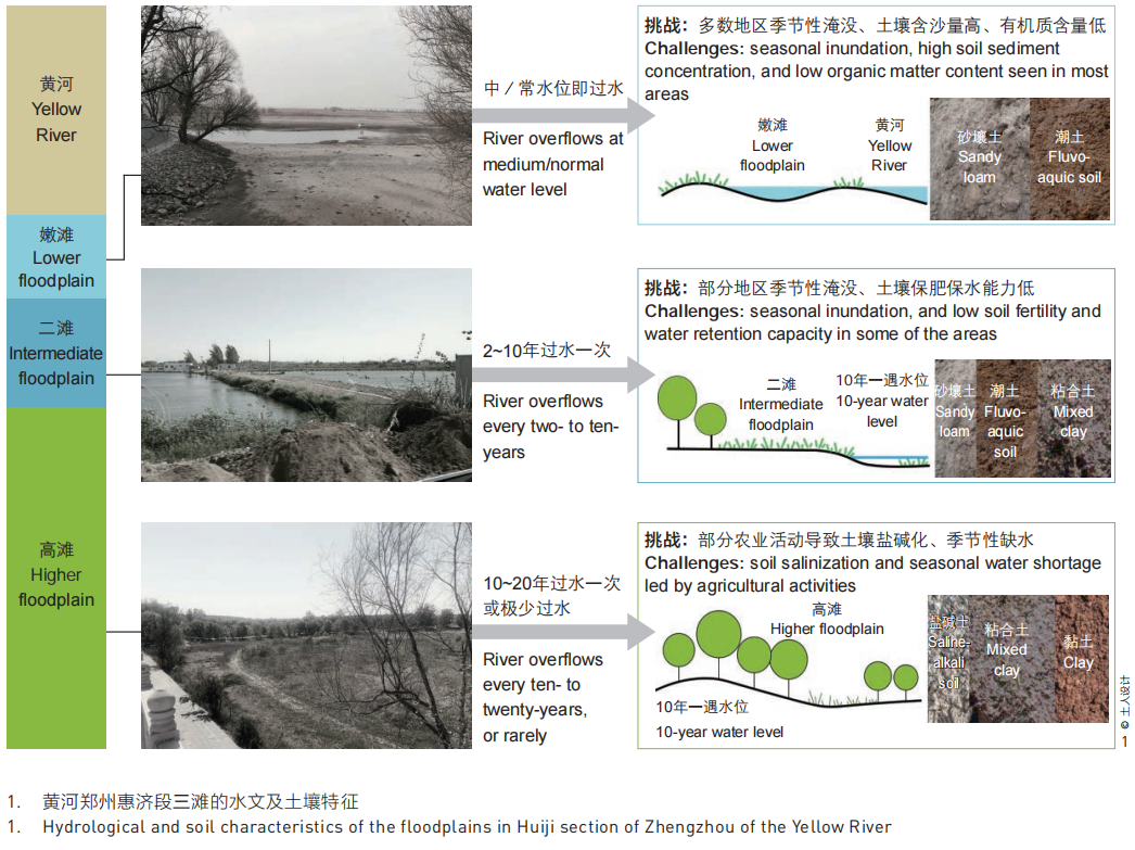
相关研究提出了“三滩分治”的基本思路,即 “在高滩上安置生态移民,满足群众居住和产业发 展需求;在二滩上开展生态治理,发展高效农业; 在嫩滩上恢复生态湿地,限制居住和生产活动”[2]。 “洪水分级设防、泥沙分区落淤、水沙自由交换” 的模式既发挥了滩区滞洪沉沙的机制,也通过差别 化防洪措施保障了合理的生产生活空间。[10][11]因此“三滩分治”的生态治理模式受到了大量关注,为 黄河滩区生态修复提供了新思路。
2 场地现状与挑战
2020年,在郑州市惠济区规划发展中心的委托 之下,北京土人城市规划设计股份有限公司对郑州 黄河滩地公园开展规划设计。郑州黄河滩地公园位 于惠济区,是郑州打造黄河流域生态保护和高质量 发展核心示范区的生态保护示范点。
2.1 项目场地现状及三滩划分情况
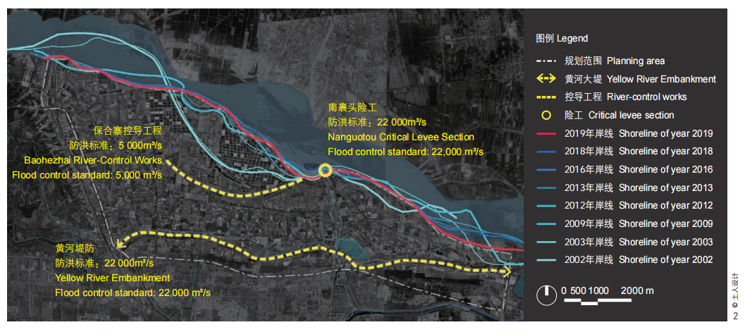
项目位于黄河下游南岸,为黄河大堤以内的黄 河滩区,总面积约44km2 。此段黄河为黄河下游的 上首,位于郑州北侧15km,比降较缓(纵、横比 降分别为1/5 000、1/7 000左右),河道内泥沙大量 淤积,水流宽、浅、散、乱,主流摆动频繁,属典 型的游荡型河段。近年来黄河上游来水来沙进入偏 枯序列,小浪底水库等工程的调水排沙作用使得该 河段主流摆幅逐渐缩小,河势越来越稳定,但项目 场地所在的小浪底至花园口之间区域仍存在无工程 控制区,洪水形成快、来势猛、预见期短,是黄河 “下大型”洪水的集中区域[12]~[14]。场地内的黄河大 堤、南裹头险工和保合寨控导工程是抵御黄河洪水 的重要工程设施,滩区本身也承担重要的蓄滞洪功 能(图2)。
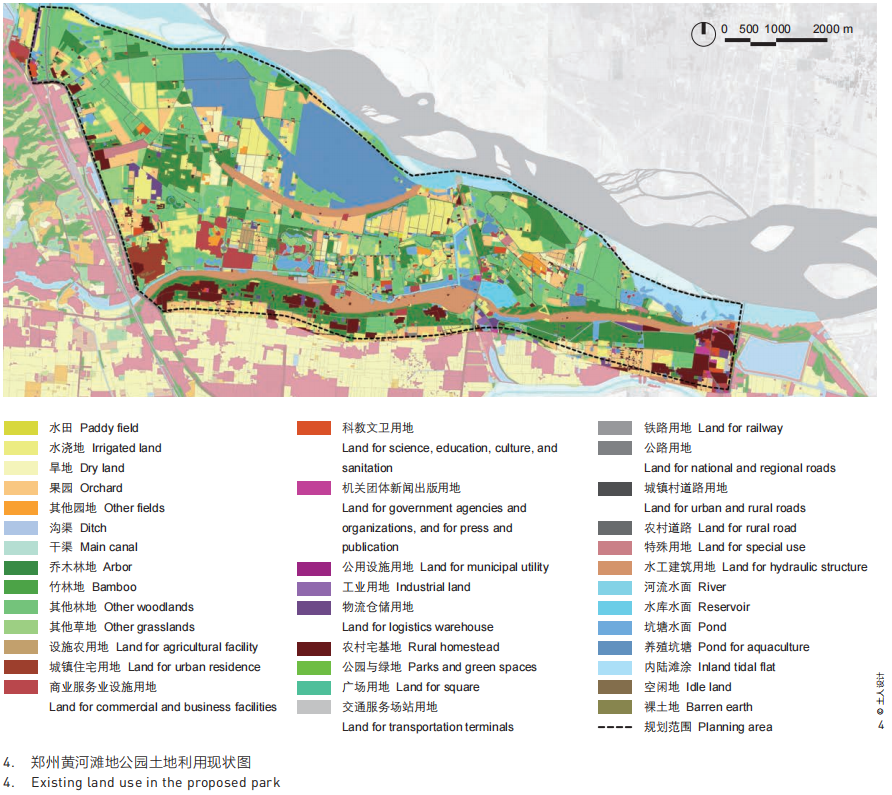
项目所在地气候属北温带大陆性季风气候, 平均气温15.7℃,最高气温42.5℃,最低气温- 10.2℃。年均降水量641mm,主要集中在6月和7月[15]。 土壤类型主要为潮土、盐碱土等[16]。滩地公园地 势整体平坦,坡度多小于5°,地表径流为西南向 东北方向(图3)。滩区内现状耕地占地7 200亩 (约480hm2 ),大多为水浇地和旱地,种植蔬菜 和草莓;鱼塘面积6 767亩(约450hm2 ),主要分 布在嫩滩区域;园地面积6 287亩(约420hm2 ), 以花圃、果园和苗圃为主。现状林地21 956亩(约 1 460hm2 ),主要为经济林与农田防护林。滩区内有古荥镇孙庄、黄河桥村两个行政村,人口约0.73 万,还拥有较多休闲农业园(图4)。
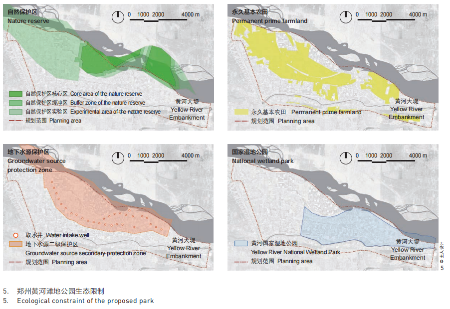
公园北部属于郑州黄河湿地省级自然保护区, 东部为郑州黄河国家湿地公园,黄河大堤以内的滩 区为郑州市地下饮用水源保护区,且包含永久基本 农田逾两万亩,滩地公园的生态保护面临多重要求 和挑战(图5)。
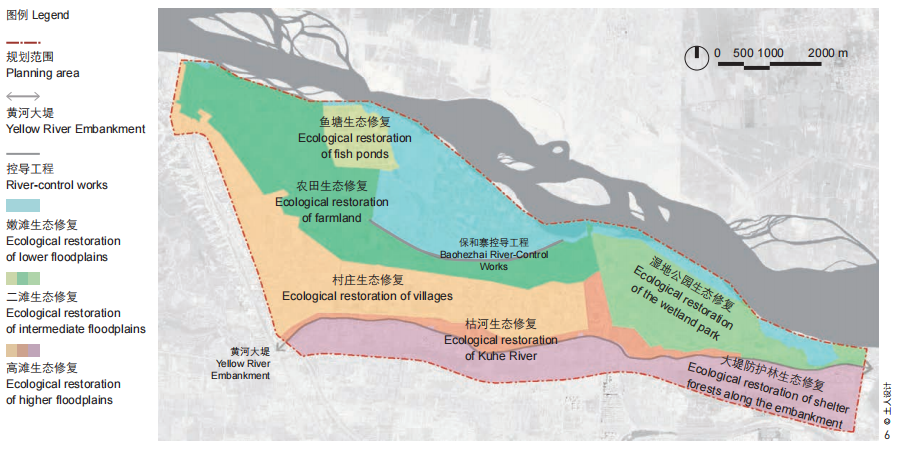
本研究结合滩区洪水淹没风险,以控导工程 及20年一遇流量(12 300m3 /s)的水位线为界划分 三滩。嫩滩为控导工程及相邻控导工程连线与水边 线合围区域,高程范围为85.77~100.74m,面积为 7.63km2 。该区域包含自然保护区核心区、缓冲区。 二滩在控导工程及相邻控导工程连线以南,20年一 遇流量水位线以北,高程范围为88.77~105.76m, 面积为14.86km2 。20年一遇流量洪水不漫滩的滩 区属于高滩,高程范围为88.87~111.92m,面积为 11.74km2 (图6)。
2.2 现状问题
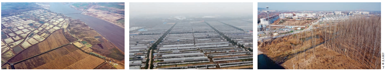
郑州黄河滩地公园所在场地因受到防洪政策、 农业活动、村庄建设、生产堤等诸多因素的影响, 自然生态系统遭受到较大的破坏(图7)。本项目 拟从生态系统服务的角度对滩地公园的现状进行评 价。生态系统服务构建了人与自然的联系,是人类 从生态系统中获得的产品和服务,包括调节服务、 供给服务、支持功能和文化服务[17][18]。从生态系统服务视角进行分析能够反映黄河流域生态保护与高 质量发展的要求。
2.2.1 调节服务
滩地公园最重要的调节服务为黄河滩区调水 调沙。然而位于控导工程以内的生产堤阻隔了嫩滩 与主河槽的水沙交换,原有大面积的滩涂湿地被人 工鱼塘所替代,造成大量泥沙淤积在河漕,加剧了 “二级悬河”②态势,容易导致横河、斜河现象,危及黄河大堤安全。
2.2.2 供给服务
滩区具有食物及水源供给的功能。滩地公园内 有基本农田两万余亩,但农业生产结构单一,粮食产量低且不稳定,滩区的农业结构处于粗放型的自 然经济状态。同时滩区作为郑州市地下饮用水源保 护区,却面临着突出的水环境问题。区域内过度使 用农药化肥的现象普遍,给维持区域生态环境和水 质安全带来了挑战。
2.2.3 支持服务
滩地公园北部的郑州黄河湿地自然保护区是中 国三大候鸟迁徙通道中线的重要节点,也是黄河中 下游最具代表性的湿地之一。然而区域内人为活动 干扰明显,人工鱼塘侵占了自然滩地,农田河渠普 遍硬化,原有生境遭到破坏,湿地生态系统萎缩, 自然植被减少,滩区支持生物多样性和稳定性的功能降低[15][19]。
2.2.4 文化服务
因滩区特殊的功能和用地管理要求,村庄及农 业园的配套设施建设存在较大阻力,现状产业单一且低端,区域经济发展水平落后。滩区内部道路体 系不完善,以生产和防汛为主要功能;道路通达性 差,且沿途体验不佳;缺乏慢行交通配套设施,难 以支撑滩地公园的休闲游憩功能,无法满足人们感 知黄河滩地独特自然景观与生态文化的需求。
3 设计策略
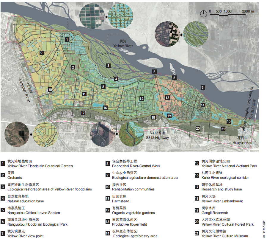
郑州黄河滩地公园是黄河郑州段生态保护核心 示范区,也是郑州城区北部的城市后花园。设计团 队期望通过三滩生态修复全方位完善生态系统的调 节、供给、支持和文化服务,突出黄河滩地的原真 性和自然特色;基于生态系统服务优化生态慢行体 验,提倡绿色的生产生活方式,进一步提升文化服务功能(图8)。
3.1 完善三滩生态修复,提升生态系统服务
项目在黄河下游滩区“三滩分治”模式的基 础上,针对滩地公园内嫩滩、二滩、高滩的水土特 征和利用状况分别提出生态修复策略,为滩地、鱼 塘、农田、河道、林地制定具体的生态修复模式, 突出黄河滩地生态景观特征,完善滩地生态系统服 务功能(图6)。
3.1.1 嫩滩生态修复
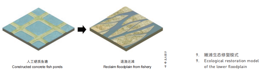
嫩滩位于郑州黄河湿地自然保护区核心区,但 人工鱼塘与生产堤的建设造成湿地面积萎缩,对黄 河生态系统和防洪功能都造成了极大影响。嫩滩生 态修复的重点是减少人为干扰,实施生态隔离,改 善生态系统服务的调节功能与支持功能。
首先通过出台湿地补偿政策,使位于自然保护 区核心区内的永久基本农田和耕地全部退出,嫩滩 其他区域内的基本农田和耕地逐步退出,不得建设 任何生产设施,实施退耕退渔、还湿还草。其次 以自然恢复为主、人工修复为辅开展生态修复。 破除位于嫩滩的生产堤,通过放淤将主槽及嫩滩 泥沙淤至高滩和二滩,增加滩地的过水能力,加 速水沙交换,与河槽一起承担行洪输沙功能;利 用黄河的水文周期、本土植物种质资源、自然肥 力等恢复原生湿地景观。种植芦苇(Phragmites australis)、白茅(Imperata cylindrica)、狗牙 根(Cynodon dactylon)等滩地优势物种,加速嫩 滩植物群落演替,逐渐形成黄河滩地原生生境[9] (图9)。
3.1.2 二滩生态修复
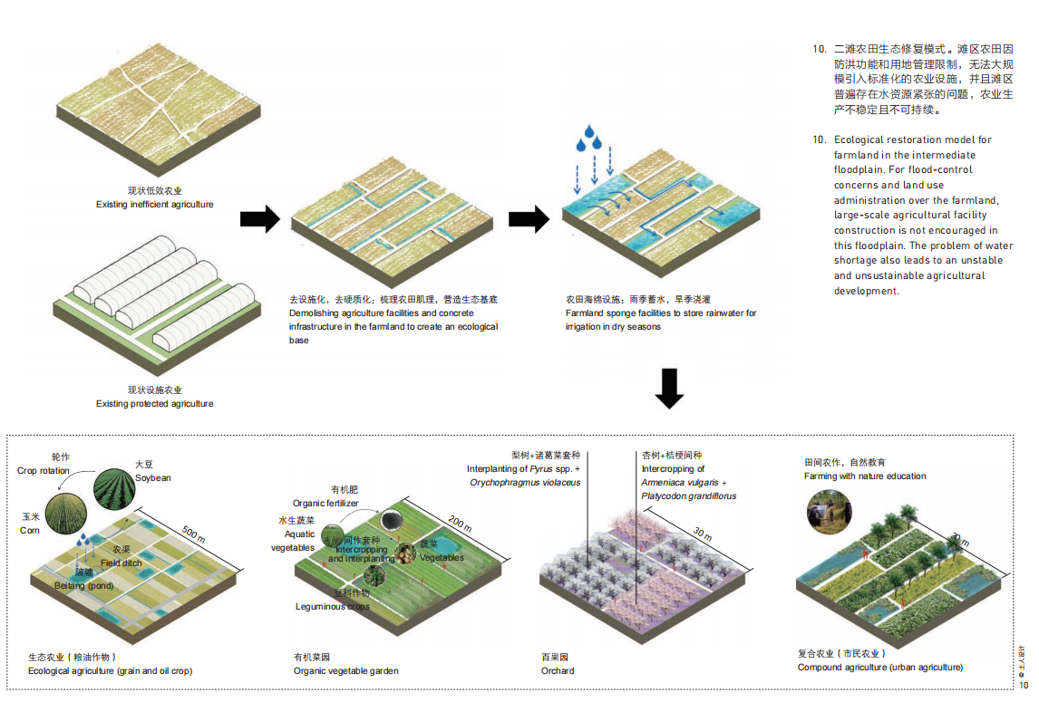
二滩面积广阔,淹没概率小,洪水风险中等, 农业生产基础较好,现状土地利用情况复杂,包括 农田、果园、鱼塘和村庄等多种类型。二滩受到人 为活动干扰较大,应全方位提升生态系统服务,促 进滩区防洪防灾、生态保护与农业发展齐头并进。
现状农田和果园生产低效低质,设施农业无序 发展。需清除不必要的农业设施,构建生态农田基 底;借鉴传统农业智慧,增加陂塘作为农田海绵设 施[20],雨季蓄水,旱季浇灌,提高滩地水源涵养能 力,同时应对黄河水量逐渐减少、土地沙化严重的 问题[15];加强水资源节约集约利用,深入开展节水 农业、循环农业、有机农业等技术研发,大力推进 农业节水,进一步缓解生产与生态用水紧张问题。 在此基础上构建复合生态农业,打造特色林果、蔬 菜、作物等种植基地,提倡轮作、间作、套种等生 产模式,提高土地利用效率,改善土壤物理和养分 结构,利于防治病、虫、草害,达到减少农药和化 肥使用及农业面源污染的目标;鼓励发展特色都市 农业,提供高品质生态游憩服务,实现生态保护与 经济发展的良性循环(图10)。
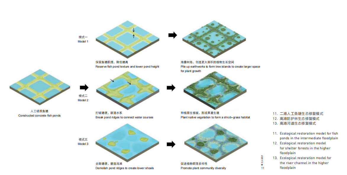
现状鱼塘往往通过工程筑塘和投放饵料维持养 殖产量,但此类简单粗暴的生产方式破坏了自然湿 地系统的稳定性,带来了严峻的水体污染问题。鱼 塘修复首先计划恢复湿地生境,促进物质循环,按 照食物链和生物与环境协同进化原理,营造良好的 水域生态环境,推动生态产品溢价(图11)。
3.1.3 高滩生态修复
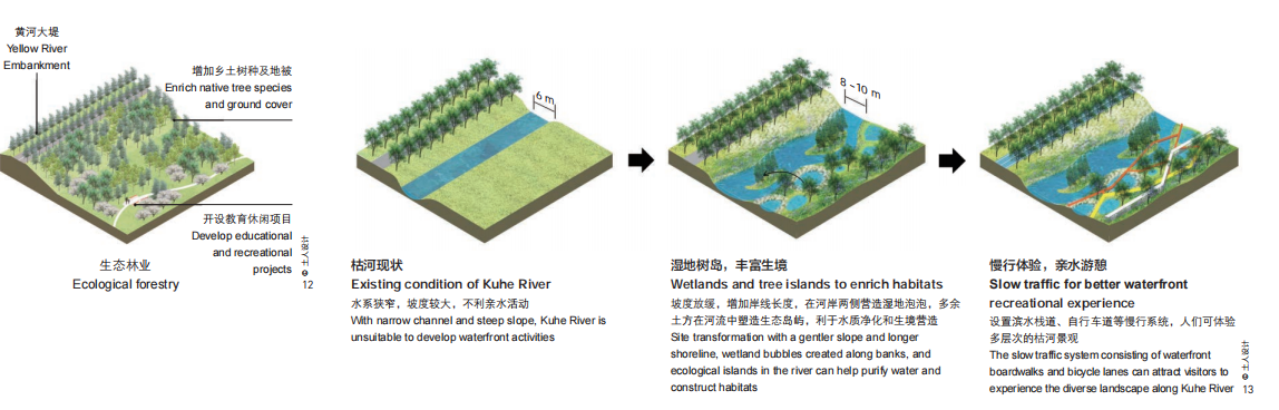
滩地公园内高滩农村居民点相对聚集,栽有成 片的人工防护林,季节性河流枯河贯穿其中。高滩 生态修复应着重提升其调节服务、支持服务与文化 服务。防护林树种单一,容易造成林地退化,影响 防护效果。通过增加乡土树种及地被,可提高生物多样性及群落稳定性[9],丰富林地的季相变化,塑造 黄河大堤生态风景线(图12)。加强对枯河的生态 治理,在河道两侧营造海绵湿地,土方就地平衡堆 叠生态树岛岛屿。这一举措一方面可以增加生态岸 线长度,扩大植被与水体的接触面积,提升水体净 化效率;另一方面可以丰富河流生境类型,形成蓝 绿交织、生机盎然的生态界面,为周边居民提供休 闲游憩的亲水场所(图13)。
3.2 构建沿黄慢行系统,优化生态感知体验
滩地公园通过内部道路交通管制和完善的公共 交通与慢行系统构建,提倡对环境低干扰的交通方 式。根据慢行尺度研究,将滩地公园划分为若干个 尺寸约为2km×2km的慢行单元。慢行单元之间为内 部车行联系道路,分散设置机动车停车场和换乘驿 站;慢行单元内部设置独立慢行道路,保证安全舒适 的慢行环境,提供多样化的慢行交通和体验方式。
慢行道路充分利用现状农村道路、田埂路,避 免对路面进行不必要的硬化,通过应用碎石路面等 自然材质契合黄河滩地原生自然风貌。新增道路的 高程确保不影响滩地的防洪滞洪功能。慢行道路沿 途设置功能完善的服务驿站,且尽可能与周边乡村 的公共服务设施、农业休闲园的旅游接待设施结合 设置,满足换乘、休憩、咨询等需求。为减少黄河 大堤对两侧慢行联系的阻隔,局部场地会结合大堤 安全防护要求设置慢行路联系两侧。
3.3 推动绿色生活方式,实现生态产品价值
滩地公园的防洪、生态、生产的复合功能属性 在较长时期内很难改变,因此需探索富有滩区地域 特色的高质量发展途径,满足人民群众对美好生活 的向往。规划提出4项策略:1)充分利用滩区生态 和人文资源,发展绿色低碳旅游,建立生态保护的 反哺机制;2)引入创意产业和业态,充分利用治 黄工程文化遗存与水利设施,发展黄河研学,推广 自然教育和大河文化,满足审美启智需求,多方位 展示治黄成就,讲好黄河故事;3)塑造黄河优农品 牌,探索生态产品价值转化途径,促进生态产品溢 价;4)积极引导绿色建筑、智慧科技等的应用,推 动绿色生产和生活方式,实现生态保护与经济发展 的良性循环。
4 结语
郑州黄河滩地公园地处黄河下游滩区的典型区 域,在黄河流域生态保护与高质量发展的背景下, 三滩生态修复的模式具有重要借鉴意义,能够统筹 推动实现防洪安全、生态安全和绿色发展等,全方 位完善生态系统服务。
首先,滩地公园所在的黄河小浪底-花园口区 间防洪形势较为严峻,加之极端水旱灾害发生的频 率和强度呈增加态势,揭示了滩区长期面临洪水威 胁的客观现实。[1][3]本项目通过嫩滩退耕退渔及还湿 还草、二滩农田海绵设施等措施增强滩区行洪滞洪 的能力;高滩在遭遇20年一遇以上洪水时可纳入行 洪滞洪空间,届时妥善转移安置滩区群众,保障大 堤两岸和滩区人民生命财产安全。
第二,通过三滩生态修复全面改善滩区生态环 境,可恢复黄河滩地原生生境,提升调水调沙、水 源涵养、水土保持、生物多样性保护、气候调节等 多种生态系统服务功能。同时,市民和游客能够获 得高品质的生态感知与文化体验,满足了公众的审 美启智需求,进一步推动了人与自然的和谐共生。
第三,应强化空间用途管制,保障“三滩分 治”模式的落实。嫩滩所在区域除必要的水利工程 之外,不安排新增建设用地指标,生态保护红线应 划尽划,产业和居民逐步外迁。二滩在不影响防洪 功能的前提下,优化永久基本农田格局,合理安排 必要的农业休闲、观光用地。高滩在充分考虑滩区 安全建设的基础上,合理调整生产布局,安排必要 的生活基础设施[3][7]。
目前,郑州黄河滩地公园在规划方案引领下正 有序开展三滩生态修复工作,形成的相关经验也随 着“三滩分治”地方标准的建立,逐渐推广应用于 黄河郑州段的其他滩区,未来可结合实际落地的 情况进一步深入研究三滩生态修复模式对生态系 统格局、质量和生态胁迫等方面的影响,以及探讨 实施后的生态适宜性、技术可行性和社会接受性等内容。
Exploration on Ecological Restoration Model for the Improvement of Ecosystem Services of Yellow River Floodplains
—A Case Study of Zhengzhou Yellow River Floodplain Park Planning and Design
1 Project Background
1.1 Ecological Characteristics of Floodplains in Lower Reaches of the Yellow River
Since the Taohuayu Valley in Zhengzhou, He’nan Province, the Yellow River comes into its lower reaches with wider channels and gentler slopes, for which floodplains are formed due to sediment accumulation, where the river is well known as the “river above the ground level” and confronted with challenges of flooding and ecological sensitivity[1][2]. Between the main channel and the Yellow River Embankment, the floodplains play an important role in flood discharge and detention, as well as sedimentation. Normally, they can carry about 10% ~ 40% flood, though inferior to the main channel, so as to reduce the flood peak and slow down the flood process[3].The floodplains, with diverse ecosystems such as wetlands, farmland, and grasslands, can also provide multiple ecosystem services of water and soil conservation, biodiversity protection, and climate regulation[4]. After the completion of the Xiaolangdi Water Control Project, the flood control ability of the lower reaches of the Yellow River has been enhanced, but the hydrological changes lead to a significant reduction of the annual maximum flood volume and highest water level, which further causing problems of wetlands lacking seasonal overflow and more land reclamation from wetlands[5][6].
The flat and open floodplains that near the main channel of the Yellow River are ideal land for plowing. By now, a large area of living and production space has been formed by a variety of land use types including farmland, orchard, forest, and construction land. Considering the impact of flooding and river channel wandering, local residents began to construct production dikes against the banks by themselves and took spontaneous repair and maintenance measures to protect the farmland and villages in the floodplains. Although favorable for living and production security, these production dikes have affected the water and sediment exchange between floodplains and the river channel, or even compromised the overall benefits of flood control[1].
1.2 Site-Specific Management Strategies for Floodplains in the Lower Reaches of the Yellow River
According to the overflow difference, the floodplains in the lower reaches of the Yellow River could be classified into lower, intermediate, and higher ones[7]~[10]. Lower floodplain refers to the shallows that emerge in dry seasons or formed by river channel wandering, aiding the main channel in flood discharge and sediment transport. Higher floodplain is located along the Yellow River Embankment, part of which was the previous claybank of the river. The terrain is comparatively high as villagers mound the soil so that villages can be free from inundation risks in slight or moderate flood events. Intermediate floodplain is located between the higher floodplain and the river-control works①. It might be flooded in certain cases and mainly serves for flood and sediment detention (Fig. 1).
1. Hydrological and soil characteristics of the floodplains in Huiji section of Zhengzhou of the Yellow River
Existing studies have proposed a theoretical framework that offers site-specific management strategies for each type of floodplains: 1) resettling locals on higher floodplain for living and industrial development; 2) implementing ecological management on secondary floodplain for high-efficiency agriculture development; and 3) restoring wetlands on lower floodplain and limiting residential and production development[2]. Graded flood control, zoned sedimentation, and free water-sediment exchange can not only help detain flood and facilitate sedimentation, but also reserve residential and production spaces by differentiated flood-control strategies.[10][11] This framework has received much attention from practitioners to verify the new approaches for ecological restoration in the Yellow River floodplains.
2 Site Profile and Challenges
In 2020, commissioned by the Planning and Development Center of Huiji District, Zhengzhou City, Turenscape started the planning and design for Zhengzhou Yellow River Floodplain Park. It is aregional demonstrative project of ecological conservation and high-quality development of the Yellow River Basin.
2.1 Site Context and Zoning of the Three Types of Floodplains
The site, with a total area of 44 km2, covers floodplains on the south bank of the Yellow River between the channel and the embankment. As the starting point of the lower reaches, this reach is 15 km north from Zhengzhou with gentle longitudinal and transverse gradients (1/5,000 and 1/7,000 respectively). However, due to severe sedimentation problems, the wide and shallow river channel frequently and unpredictably wanders. In recent years, flood and sediment from the upper reaches have decreased and the wandering of the river channel alleviates, benefiting from the water transfer and sediment dredging by projects such as Xiaolangdi Reservoir. However, the reach between Xiaolangdi Reservoir and Huayuankou still faces problems of rapid and unforeseeable floods, where the “large floods from the lower reaches” happen frequently due to the lack of engineered measures[12]~[14]. Floodplains in the site can function to store and detain floods, together with important engineering infrastructures such as Yellow River Embankment, Nanguotou Critical Levee Section, and Baohezhai River-Control Works (Fig. 2).
2. Shoreline changes and existing flood-control projects in Huiji section of Zhengzhou of the Yellow River. Changes in the shoreline represent the impact of the wandering channel on the floodplains; and the river-control works are to guide the river flow and protect the embankment.
Under the north temperate continental monsoon climate, the site is featured with an average temperature of 15.7 °C (42.5 °C the maximum and –10.2 °C the minimum) and an average annual precipitation of 641 mm, mostly in June and July[15]. Fluvo-aquic soils and saline-alkali soils are mostly seen on the site[16]. The terrain generally slopes down from the southwest towards the northeast, roughly less than 5° (Fig. 3). Regarding the existing land use, farmland in the floodplains covers an area of approximately 480 hm2, most of which are irrigated land and dry land planted with vegetables and strawberries; fish ponds mainly in the lower floodplain cover about 450 hm2; the land for gardens is about 420 hm2, mainly occupied as nurseries and orchards; and forest land with an area of 1,460 hm2 consists mainly of economic forests and shelter forests for farmland. Sunzhuang Village and Huangheqiao Village of Guxing Town sit in the site, with a total population of about 7,300, develop leisure agriculture (Fig. 4).
3. Existing site condition of the proposed park
4. Existing land use in the proposed park
Challenges and requirements of ecological restoration in the floodplain park include natural protection—with Zhengzhou Yellow River Wetland Provincial Nature Reserve located in the north and Zhengzhou Yellow River National Wetland Park in the east; protection of underground source of drinking water in the floodplains; and governance of a large area of permanent basic farmland (Fig. 5).
5. Ecological constraint of the proposed park
The zoning of the floodplains was conducted by the standards concerning inundation risks, location of the river-control works, and the water level in a 20-year flood (12,300 m3/s) event. Lower floodplain is identified as the area between the river-control works and the water boundary, covering an area of 7.63 km2 in the elevation of 85.77 ~ 100.74 m. The core area of the nature reserve and buffer zones are also included. Secondary floodplain (14.86 km2) located in the south of the river-control works are prone to the 20-year flood, where the elevation ranges from 88.77 m to 105.76 m. Finally, higher floodplain is free from the 20-year flood, occupying an area of 11.74 km2 in the elevation of 88.87 ~ 105.76 m (Fig. 6).
6. Floodplain zoning and ecological restoration units of the park
2.2 Existing Problems
Under current flood control policies and impacted by agricultural activities, construction of villages and production dikes, etc., the ecosystem of the site has been heavily damaged (Fig. 7). This project intends to evaluate existing site conditions by measuring its ecosystem services. Ecosystem services, linking human and the nature, are normally categorized as regulating, provisioning, supporting, and cultural services, are products and benefits that humans obtain from the ecosystem[17][18]. Analysis on ecosystem services can help come up with solutions that could meet the requirements of both ecological restoration and high-quality development for the Yellow River Basin.
Existing condition of the site. The lower floodplain has been converted into fish ponds, seeing heavy human interference and serious wetland and vegetation loss. The intermediate floodplain covers a large area of farmland with unsustainable production patterns and vegetation diversity also decreases. The higher floodplain is featured with homogeneity of tree species; the natural habitats and the river channel has been heavily impacted by human activities.
2.2.1 Regulating Services
Water and sediment regulation is the core regulating service the floodplain park could offer. However, the production dikes constructed in the north of the river-control works block the water–sediment exchange between the lower floodplain and the main river channel. Worse, tidal flat wetlands have been largely converted into constructed fish ponds, resulting in heavy sediment which aggravates the reaches’ condition of being a “secondary-level suspended river”②, and the diagonal river would endanger the total Yellow River Embankment.
2.2.2 Provisioning Services
The floodplains are significant source of crops and water for local people. Though large in the area of the prime farmland, the floodplains are in a homogeneity of agricultural production structure. The existing extensive agriculture have further caused a low and unsustainable grain yield. Severe water pollution problems also exist in the floodplains due to the overuse of pesticides and fertilizers, bringing about hazards to the underground drinking water source.
2.2.3 Supporting Services
Zhengzhou Yellow River Wetland Nature Reserve in the north of site, a typical wetland in the middle and lower reaches, is a key node in China’s three main corridors for bird migration. However, more and more concrete structures damage the existing natural habitats, encroach on the floodplain and wetland ecosystems, and decrease vegetation coverage, declining the floodplains’ performance in maintaining biodiversity and biostability[15][19].
2.2.4 Cultural Services
Due to the restrict land use administration over the floodplains for safety concerns, supporting facility construction in villages and agricultural parks is not encouraged. As a result, existing industry and economic development on the site keeps a low level. As roads within the floodplains are mainly built for production and flood prevention purposes, the poor accessibility and experience to or along roads without facilities to support slow traffic which encourages walking and cycling may neither meet visitors’ recreational demands nor celebrate the unique floodplain landscape or its eco-culture.
3 Design Strategies
The proposed floodplain park aims to provide a demonstration case for the ecological restoration in the lower reaches of the Yellow River, and to create as a recreational destination for the city. Guided by the site-specific management for floodplains, the project will first improve the ecosystem’s regulating, provisioning, supporting, and cultural services by celebrating the floodplains’ natural quality; and then advocate a greener lifestyle and production mode by optimizing the slow traffic system, so as to enhance the cultural services (Fig. 8).
8. Site plan of Zhengzhou Yellow River Floodplain Park
3.1 Three Types of Floodplain Restoration to Improve Ecosystem Services
Based on the concept of site-specific management for floodplains, the project proposed detailed plans on floodplains, fish ponds, farmland, river channels, forests, etc. respectively for the lower, intermediate, and higher floodplains according to their distinct hydrographical characteristics and land use. The ecosystem services of the Yellow River floodplains are to be improved by reshaping the ecological landscape on the site (Fig. 6).
3.1.1 Lower Floodplain Ecological Restoration
Although adjacent to a nature reserve of wetlands, the lower floodplain has suffered from wetland loss due to the construction of fish ponds and production dikes, seriously impacting the ecosystem’s regulating and supporting services and its flood control ability. Thus, the ecological restoration in this area concentrates is to limit human interference and implement rigid ecological protection.
First, by introducing wetland compensation policies, all permanent prime farmland and arable land within the core area of the nature reserve should be withdrawn, and those in other parts of the lower floodplain can be withdrawn by phases. Production infrastructure construction is not allowed while preserving space for wetlands and grasslands. Second, nature-based restoration approaches are proposed including demolishing production dikes and enhancing the overflow capacity of the floodplains via warping measures which take sediments from the main channel going through the lower floodplain then to the intermediate and higher floodplains. In this process, the improved efficient water–sediment exchange can reduce flood discharge and sediment transport stress to the main channel. Other restoration strategies include improving and encouraging hydrological cycle, native plant germplasm sources, and the natural fertility. Dominant species on the floodplains such as Phragmites australis, Imperata cylindrica, and Cynodon dactylon can also accelerate plant community succession and the establishment of native habitats[9] (Fig. 9).
9. Ecological restoration model of the lower floodplain
3.1.2 Intermediate Floodplain Ecological Restoration
The intermediate floodplain is a larger area of medium inundation risk. Centuries of agricultural production has shaped the area into a complex land-use pattern, ranging from farmlands, orchards, fish ponds, and settlements. Considering the large human interference, it is necessary to improve all the ecosystem services in flood and disaster prevention, while reinforcing ecological conservation and agricultural development.
Agricultural yield of existing farmland and orchards are low and inadequate, while the protected agriculture develops lacking supervision. One strategy is to establish an eco-farmland base by replacing part of artificial facilities with local natural measures. For instance, beitang (a retention pond in traditional agriculture) can perform as sponge facilities[20] that retain water in rainy seasons and irrigate the farmland in dry seasons. Gradually, the floodplains’ water conservation capacity can be improved to cope with water volume decrease and land desertification[15]. Meanwhile, technical advances in water-saving, recycling, and organic agriculture can help conserve water resources to better support production and ecological conservation . The further introduction of the compound agriculture will cultivate a diversity of forests, orchards, vegetables, and crops through varied crop rotation, intercropping, and interplanting. This could improve both land use efficiency and physical and nutrient structures of the soil to help prevent plant diseases, pests, and weeds, by which non-point source pollution, as well as the use of pesticides and fertilizers, could be reduced. The synergetic and high-quality development of urban agriculture and eco-recreation can bring about both ecological and economic benefits (Fig. 10).
10. Ecological restoration model for farmland in the intermediate floodplain. For flood-control concerns and land use administration over the farmland, large-scale agricultural facility construction is not encouraged in this floodplain. The problem of water shortage also leads to an unstable and unsustainable agricultural development.
In current aquaculture, concrete fish ponds and artificial nutrient feed have commonly adopted, which further damages natural wetland stability and aggravates water pollution. In response, the project proposes to restore wetland habitats following principles of food chain and coevolution, for better material exchange. While the water environment is improved, higher-quality aquatic products may also drive the eco-economy development (Fig. 11).
11. Ecological restoration model for fish ponds in the intermediate floodplain
3.1.3 Higher Floodplain Ecological Restoration
Higher floodplain homes many villages, a large area of shelter forests along the Yellow River Embankment, and the seasonal Kuhe River, where regulating, supporting, and cultural service enhancement is the primary task to the ecological restoration. Considering the possible land degradation and inefficient protection resulted from the homogeneity of tree species, the project first enriches native tree species and ground cover for higher plant community stability[9]. The diverse forests will create a landscape of seasonal sceneries along the embankment (Fig. 12). In Kuhe River restoration, the project plans to create sponge wetlands along river banks while piling up earthworks to build tree islands. This strategy not only lengthens the shoreline for better water purification, but also diversifies habitats to form a robust blue–green ecological interface, increasing citizens’ recreational opportunities of accessing to the river (Fig. 13).
12. Ecological restoration model for shelter forests in the higher floodplain
13. Ecological restoration model for the river channel in the higher floodplain
3.2 Riverside Slow Traffic System to Optimize Ecological Perception
The project suggests a low-impact mode of traveling by limiting vehicle traffic and introducing public traffic and slow traffic system (walking and cycling) in the floodplain park. According to relevant research on slow traffic, the park is to be divided into a series of units (2 km × 2 km). These units will be connected via roads for shuttles, while vehicle parking lots and transfer stations are provided in several nodes. In each unit, paths for walking and cycling will be separated to provide safety and diversified experience for all visitors.
Roads for slow traffic are to be constructed by renovating the existing rural roads and field ridges with natural materials such as gravels, where hard paving is avoided. The newly constructed roads should not affect the floodplains’ flood control ability. Service stations along the slow traffic roads should be fully equipped, together with public facilities for villages nearby and visitors’ centers in agricultural parks, so as to meet visitors’ demands for transfer, rest, and tourism information. To linking the slow traffic units on the both side of the river, bridges can be constructed under the requirement of flood control.
3.3 Exploration of Green Lifestyle and Ecological Products
Since the floodplain park is primarily planned to serve for the long-term flood control, ecological restoration, and production purposes, the project proposed four other strategies to foster high-quality and distinct local development. First, encourage environmental-friendly tourism utilizing the ecological and cultural resources which can in turn support ecological conservation. Second, introduce innovative industries and projects on cultural heritage and water conservancy facilities from historical Yellow River management legacy. During the on-site education, visitors can better appreciate the aesthetics of nature and the history of the mother river. Third, expand the market for local ecological products to realize greater value. Fourth, explore green production mode and lifestyle with technological support, for a synergy between ecological conservation and economic development.
4 Conclusions
The floodplain park, putting the site-specific management strategies into practice, can provide an exemplar for ecological restoration of other floodplains in lower reaches of the Yellow River, under the national policy of large river protection. The strategies adopted may improve the site’s ecosystem services holistically, especially regarding flood control, ecological security, and green economy.
First of all, the floodplains have a long-term, high flood risk, while extreme flooding and drought events happen more frequently and fiercely.[1][3] Thus specific strategies were proposed for different floodplains. For instance, the flood discharge and detention capability can be enhanced via land preservation of wetlands and grasslands by withdrawing farmland and fish ponds in the lower floodplain, and farmland sponge facilities constructed in the secondary floodplain. The higher floodplain can also be inundated when 20-year or more serious flood events occur, and all the people in the floodplains shall be properly relocated.
Second, by restoring the ecological environment via differentiated strategies for the three types of floodplains, ecosystem services such as water and sediment regulation, water and soil conservation, biodiversity protection, and climate regulation can be improved. Meanwhile, citizens and visitors can be inspired by the aesthetics of natural landscapes and cultural heritages, re-harmonizing the human–nature relationship.
Third, land use in the floodplains should be regulated to ensure the implementation of ecological restoration strategies. For the lower floodplain, no more construction land is allowed except that for necessary water conservancy projects; ecological red lines should be strictly delimited; and industries and residents should be gradually relocated. For the secondary floodplain, some of the permanent prime farmland can be redeveloped for agricultural tourism while guaranteeing the implementation of flood control measures. As to the higher floodplain, necessary daily infrastructure can be planned and productive activities well adjusted, in addition to flood control considerations[3][7].
Under the guidance of the floodplain park planning, ecological restoration of the three types of floodplains are under implementation. This demonstrative case, together with the launch of relevant technical standards, can provide reference for other floodplains in Zhengzhou section of the Yellow River. Further study on floodplain ecological restoration may focus on the efficiency in improving the pattern and quality of ecosystems and reducing ecological threat, as well as promoting the ecological suitability, technical feasibility, and social acceptability after its implementation.
Project Information
LOCATION: Zhengzhou City, He’nan Province, China
AREA (SIZE): 44 km2
CLIENT: Planning and Development Center of Huiji District, Zhengzhou City
LANDSCAPE DESIGN: Turenscape
CHIEF DESIGNER: Yu Kongjian
PROJECT TEAM: Shi Chun, Gong Yao, Xu Xingzhong, Xiong Wei, Yao Suke, Yang Fan, Zhang Yingwu, Li Bo, Chen Yangyang, Lin Li, Xu Kai, Yuan Jingna, Chang Hexing, Sun Bo, Gao Bing, Zhang Peijie, Yu Wence, Hu Xiabin, Wei Danning, Yue Yushan
DESIGN PERIOD: January, 2020 ~ March, 2021
CONSTRUCTION PERIOD: August, 2020 to present
References
[1] Zhang, J., Liu, J., Wan, Z., & Lu, J. (2018). Channel Morphology Evolution and Corresponding Coping Strategy in the Lower Yellow River “Study on Ecological Reconstruction and Management of the Floodplains in the Lower Yellow River” (I). Yellow River, 40(7), 1-6, 37.
[2] Zuo, Q. (2020). Critical problems and construction of synergy governance system in the beach area of the lower Yellow River. Science and Technology Review, 38(17), 23-32. doi:10.3981/j.issn.1000-7857.2020.17.002.
[3] Tian, Y., Sun, Y., Li, Y., & Ma, J. (2019). Study on the Management Strategy of the Floodplain of the Lower Yellow River. Yellow River, 41(3), 16-20, 35. doi:10.3969/j.issn.1000-1379.2019.03.004.
[4] Xu, X., Tan, L., & Li, Y. (2020). Thoughts and Suggestions on Land Use Control in Beach Areas of the Lower Yellow River. Online publication. Consulting Research Center of Ministry of Natural Resources.
[5] Xia, J., Li, J., & Zhang, S. (2016). Channel Adjustments in the Lower Yellow River After the Operation of Xiaolangdi Reservoir. Yellow River, 38(10), 49-55. doi:10.3969/j.issn.1000-1379.2016.10.010
[6] Tian, Y., Qu, B., Li, Y., & Gu, Z. (2019). Research and Perspective on Floodplain Treatment in the Lower Yellow River. Yellow River, 41(2), 14-19. doi:10.3969/j.issn.1000-1379.2019.02.004
[7] Pei, Z. (2014). Analysis of Land Ecological Utilization Regionalization Construction in Beach Area of Lower Yellow River. China (International) Water Summit Forum—2014 River and Lake Health and Ecological Civilization Construction Conference Papers (pp. 222-227). Hu’nan, China.
[8] Zhang, M., Zhang, Y., Zhu, W., Liao, C. & Zhao, S. (2010). Wetland Restoration Models in Zhengzhou Yellow River Nature Reserve, Henan Province. Wetland Science, 8(1), 67-73.
[9] Wu, S., Wang, H., Li, Q., & Wang, P. (2021). Study on landscape plant design and ecological restoration in floodplain area of the Lower Yellow River—A case study of floodplain area of Yellow River in Changyuan City, Henan Province. Jiangsu Agricultural Sciences, 49(8), 141-148, 157. doi:10.15889/j.issn.1002-1302.2021.08.025
[10] Zhang, J., Liu J., Li, C., & Cui, Z. (2018). Management of Floodplain and Ecological Reconstruction Modes Development in the Lower Yellow River—“Study on Ecological Reconstruction and Management of the Floodplains in the Lower Yellow River” (IV). Yellow River, 40(10), 1-5, 24.
[11] Liu, S., He, Y., Cui, M., Zhang, J., Wan, Z., Cui, C., ... Wang, J. (2013). Research on the key technology of comprehensive management of beach area in the lower Yellow River. Retrieved from https://d.wanfangdata.com.cn/cstad/ChFDc3RhZE5ld1MyMDIxMDgwMhIKMTQwMDQ3MDA0ORoIamJjaDZwbDE%3D
[12] Zhengzhou Huiji District Flood Control Command. (2019). Flood Control Plan of Yellow River in Huiji District. Unpublished data.
[13] Yan, C., Yuan, G., Li, Z., Liu, X., & Ye, Y. (2020). Analysis of Morphological Change of the Yellow River in Zhengzhou Section Based on RS. Yellow River, 42(1), 21-26. doi:10.3969/j.issn.1000-1379.2020.01.005
[14] Guo, H., He, X., & Shi, S. (2012). Siltation and Erosion in Zhengzhou Section of the Yellow River Channel and Its Influencing Factors. Yellow River, 34(3), 4-5. doi:10.3969/j.issn.1000-1379.2012.03.002
[15] Yao, X., Wang, X., Hu, Y., Chen, Y., He, P., & Tian, G. (2021). Study on diversity of herbaceous plants along the Yellow River Wetland in Zhengzhou City. Jiangsu Agricultural Sciences, 49(1), 186-191. doi:10.15889/j.issn.1002-1302.2021.01.034
[16] Song, X., Wang, C., Peng, Z., & Yang, H. (2007). Study on Integrated Development by Taking Forestry as the Main of Floodplain Area of the Lower Yellow River. Yellow River, 29(12), 12, 14. doi:10.3969/j.issn.1000-1379.2007.12.006
[17] Daily, G. C., Ouyang, Z., Zheng, H., Li, S., Wang, Y., Feldman, M., ... Ruckelshaus, M. (2013). Securing Natural Capital and Human Well-Being: Innovation and Impact in China. Acta Ecologica Sinica, 33(3), 669-685. doi:10.5846/stxb201212311905
[18] Yu, K. (2020). Designing and Building a Beautiful City with the Vision of Ecological Civilization. Renming Luntan Xueshu Qianyan, (4), 18-36. doi:10.16619/j.cnki.rmltxsqy.2020.04.003
[19] He, X., Zheng, D., Guo H., & Ma, G. (2014). The Vegetation Species Diversity and Its Response to the Human Activities in Zhengzhou Yellow River Wetland Reserve. Wetland Science, 12(4), 459-463. doi:10.13248/j.cnki.wetlandsci.2014.04.008
[20] Yu, K. (2019). Large scale ecological restoration: empowering the nature-based solutions inspired by ancient wisdom of farming. Acta Ecologica Sinica, 39(23), 8733-8745. doi:10.5846/stxb201905311146
