Ecological infrastructure leads the way: the negative approach and landscape urbanism for smart preservation and smart growth
- 摘要:
- For the last few centuries of the urbanization process the Gray Infrastructure has led the way of urban growth and defined the urban form, now it time for the Green Infrastructure (Ecological Infrastructure) to lead the way and define the urban growth pattern, and it is the time to go the other way around, namely to take the Negative Approach. Ecological Infrastructure Leads the Way:The conventional approach for economic centered urban development planning failed to meet the challenges of swift urbanization and sustainability issues in China. The “Negative Approach” defines an urban growth pattern and urban form through the identification and planning of Ecological Infrastructure, instead of the conventional approach based on the projection of population growth and planning of civil infrastructure (Gray Infrastructure). The Negative Approach is a systematic method that carries on the concept of landscape urbanism and has evolved from the pre-scientific model of Feng-shui as the backbone of human settlement in ancient China. It is also deeply rooted in the 19th century notion of greenways as recreational infrastructure, the early 20th century idea of green belts as urban form makers, and the late 20th century notion of ecological networks and Ecological Infrastructure (EI) as a biological preservation framework. EI is composed of critical landscape structure that is strategically identified and planned to safeguard the various natural, biological, cultural and recreational processes across the landscape, securing natural assets and ecosystem services that are essential for sustaining humanity. EI functions as an effective tool for smart growth in the context of rapid urbanization, and is planned ahead of time, anticipating the scale, context and configuration of future urban development patterns. EI is strategically planned and developed using less land but more efficiently preserving the ecosystems’ services. Using Taizhou City as a case study, this chapter demonstrates how the Negative Approach can be practiced and how to use EI as a tool to guide and frame sustainable urban development. At the fringe of survival, this paper demonstrates that the implementation of the Negative Approach is essential in China for Smart Preservation and Smart Growth.
文献来源:Kongjian Yu, Ecological infrastructure leads the way: the negative approach and landscape urbanism for smart preservation and smart growth[M].Applied Urban Ecology: A Global Framework , 2014: 152-166
1 Introduction
1.1 Urbanization in China Challenges Survival
China’s urbanization has been considered to be an unprecedented phenomenon in Chinese history as it is in the world. According to the UN report (UN 2007), at the end of 2006 China's total population was 1.3 billion, 44 percent of it residing in urban areas; this number will reach 70 percent by 2035. Three facts make this projection more meaningful:
(1) The population is spatially unbalanced: about 94 percent of the population lives on approximately 46 percent of the land, mainly in the east part of China;
(2) The scarcity of natural resources: China possesses 21 percent of the world’s population but only 7 percent of the world’s fresh water and other natural resources. The water volume consumption per capita in China is one fourth of the world average;
(3) A landscape with rich cultural heritages: China has a continuous history of civilization of more than five thousand years, and virtually every inch of the land is part of the cultural heritage.
These facts have imposed two challenges to landscape and urban planning in China:
(1) Sustainability: The first challenge is about ecological and environmental sustainability. While thousands of dams lie across almost all rivers in this country, a broader population is exposed more than ever to disastrous natural forces, as demonstrated by China’s numerous floods and droughts each year. In the north desertification is in a crisis situation. Each year 3,436 square kilometers of land is being turned into desert, and this figure is increasing every year. At present, the total area of desertification accounts for about 20 percent of the whole country, furthermore, about 5 billion tons of soil erode yearly into the ocean (Jiang and Liu 2004, Zhao et al. 2004). Statistics show that in the past 50 years 50 percent of China’s wetlands have disappeared and 40 percent of the surviving wetlands have been polluted (Chen, Lü and Yong 2004).
The underground water level drops every day. In Beijing for example, the underground water overuse is 110 percent, and each year the underground water level drops by one meter. Two thirds of the 662 cities now lack sufficient water and not a single river in the urban and suburban areas remains unpolluted. If present trends are not reversed, the World Bank forecasts that by 2020 there will be 30 million environmental refugees in China due to water stress; more than half of China’s 662 cities will suffer from water shortages, affecting 160 million people; 90 percent of cities’ groundwater deposits and 75 percent of rivers and lakes will be polluted. While the GDP growth rate in the past twenty years is impressive in most Chinese cities, the annual loss caused by the environmental and ecological degradation is now between seven and twenty percent of the GDP. This is equal to or even higher than annual GDP growth (Guo 2004).
These are all by-products of China’s double-digit GDP growth rate and the nation’s swift process of urbanization. One can only ask: Is this sustainable? Can we survive the fast deterioration of the environment and ecology? How can landscape and urban planners play a role to meet these unprecedented challenges?
(2) Cultural and spiritual integrity: The second challenge is the loss of our spiritual homeland. Every piece of land and all elements in the landscape are inhabited by various spirits where our ancestors were buried. The trend toward materialism is taking over China at a rapid rate. The Dragon Hills (sacred hills) that housed numerous villages in rural China have been bulldozed. Meaningful and sacred streams and ponds in front of the villages have been filled or channeled in the name of flood control. Landscapes have become commercialized. Gradually, we have lost our spiritual connection to our land and to the earth.
How can landscape and urban planners assume the role to protect and rebuild such spiritual connections through the design of our physical environment?
In order to meet these two challenges, the methodology of landscape and urban planning has to be reversed.
1.2 The Failure of the Conventional Approach in Urban Development Planning.
Aside from other social and political reasons, the physical planning approach in the urban development planning field is responsible for the ecological and environmental degradation as well as the loss of cultural and spiritual landscape. The Chinese system of urban planning was inherited from the former socialist Soviet Union. The physical planning of urban development was an extension of the social and economic development planning exercise. The single most important basis for urban development planning is population projection, upon which urban land use, resources allocation, functional zoning and built infrastructure plan are based. In most of the cases the population projection for the long-term (20 years) and even the short term (5 years) is never correct, or even nearly correct, partly due to changing government policy.
For example, in 1986 the population of Shenzhen was estimated to become 1.1 million in 2000, but the actual number turned out to be 7 million by the end of 2000. The same is true for Beijing and Shanghai (Yu et al. 2005a, b). This model of urban development planning initiated large-scale technocratic projects and mono-functional simplification. Nature was not considered as a system and zoning was directed by economic principles. As noticed in other Soviet influenced countries: “Destruction of traditional landscape systems and ecological destabilization of landscapes, with extensive erosion, soil salinization, forest dieback and water and soil pollution, were visible results of this process,” (Jongman 2001- page?). As a result, planning of land use, as well as facilities and infrastructure can never catch up with the ever expanding population, and the urban boundary, following the extension of infrastructure, just keeps moving across the unplanned rural land indiscriminately. Critical cultural heritage sites and natural habitats are getting lost before any conservation plans are carried out. In this conventional approach any environmental conservation planning, historical protection planning and green system planning, or even flood control planning was subordinate to the comprehensive master planning, which does not cover the rural area beyond the urban development boundary. This shortcoming of the conventional planning system has recently been widely noticed (Yu et al. 2005a, b), but changes occur slowly.
In addition to the technical failure of this economic development oriented planning system, the shift of systems from a planned central economy to a market one weakens urban planning power. Physical planning is being subordinated to a socialist reference, as results are observed in a “fried egg” city form. After the reform in the 1980s, the “Leap Forward” type of city was able to show new development zones, a science center and new university cities, which virtually leap out of the master plan area and beyond the former greenbelt, or any comprehensive plan.
It is well recognized that urban planning is playing a less important role in development control and it has been widely recognized that the conventional economic oriented approach to urban development planning failed (Gaubatz 1999, Yeh and Wu 1999, Cheng and Masser 2003, Jim and Chen 2003) . For many years the major driving force of urban development has been road infrastructure and the developed urban area.
As a result Chinese urban planners are facing a huge challenge and are required to modify the urban planning system from a centrally planned, to a transitional economy reform. Action for a revolutionary change in planning methods was called upon in the past decade (Yeh and Wu 1999, Wu 2003, Yu et al 2005a,b, Zhao 2003, 2004, Yang 2003, Zhang 2003), Among them, the “Negative Approach” was proposed (Yu et al 2005a,b, Yu and Padua 2006), as a counterpart to the conventional “positive” approach in the sense of economic urban development. The “Negative Approach” is argued in the following three aspects:
(1) Rethinking the conventional urban planning model: It is argued that the “population speculation-land use- infrastructure layout” has been proven invalid in dealing with the swiftness of urban development issues and is largely responsible for the degradation of ecological conditions and the chaotic situation of the current Chinese cities. Therefore a revolutionary change to the planning methodology is necessary. The conventional planning approach will simply point out where to develop but will not be able to show efficiently where development shall not take place for the sake of environmental sustainability and cultural heritage preservation.
(2) A reversed approach to create Ecological Infrastructure (EI): As opposed to the conventional approach, which gives priority to economic development, the architectural development and built infrastructure the “Negative Approach” to urban planning is a landscape urbanism approach. This gives priority to the identification and planning of Ecological Infrastructure, which integrates landscape security patterns (Yu 1996) in safeguarding critical natural processes and biodiversity conservation, as well as securing the integrity and authenticity of the cultural heritage across landscapes (Yu et al. 2005a,b).
(3) A negative form of a city pattern by positively defining Ecological Infrastructure: As opposed to the conventional (“positive”) approach to urban development, in which urban growth is defined by built, gray infrastructure made up of roads and pipes that provide services for urban development, the “Negative Approach” acts as the green and un-built Ecological Infrastructure (EI), and acts as a framework for urban growth and definition of urban forms. EI is used not only as a tool for smart preservation (effectively preserving the natural, biological and cultural processes), but also as a tool for smart growth and creation of good urban form, guiding the pedestrian open space system in a compact city. It is argued that the first and most important principle for better urban development is to determine where not to develop (Yu et al 2005a,b, Benedict 2006 p.12).
The key in the “Negative Approach” is planning the EI and its subsequent application to shape the urban growth.
1.3. Green Infrastructure Leads the Way: The Negative Approach and Landscape Urbanism
The idea and practice of the “Negative Approach” towards urban development planning, in which landscape is first planned as infrastructure as well as an urban form maker, is certainly not a whimsical concept. It has become deeply rooted in both the Eastern and Western planning theories and practice, belonging to an ecological planning approach typically referred to under the flag of McHarg’s design with nature theory (1969), trying to provide land use and urban planning with a solid ecological basis. The Negative Approach can be more fashionably and partially described in the context of “landscape urbanism”, which Charles Wadheim described as: “a disciplinary realignment in which landscape replaces architecture as the basic building block of urbanism” (Wadheim 2007, page?). Here landscape was considered as an infrastructure of processes and as a field of operation (Corner 2003, 2007)..
1.3.1 Feng-shui: Landscape as Spiritual Linkage and Carrier of Genius Loci
The first tradition, or the pre-scientific model, of the Negative Planning theory is the Chinese ancient art of geomancy, or Feng-shui, which always give priority to the natural pattern and processes of Qi (or breath)( Lip 1979, Skinner 1982, Rossbach 1983, Yu 1994, 1996). Placed in order from large to small, the whole national landscape (mountains and water courses) was considered as an interconnected dragon vein and a network of Qi movement. A sacred landscape infrastructure in the fractal form (Yu 1994) is a given and forbidden pattern that any human actions have to come to terms with, such as establishment and construction of villages and cities, roads, bridges and even tombs. In this sense the protected sacred landscape formed the spiritual backbone or network of the live sustaining environment and then became/ becomes? the infrastructure that bares genius Loci (Yu 1996).This tradition of landscape thinking still flourishes in rural China and has, for thousands of years, created the Chinese landscape full of survival implications and spiritual bearings.
1.3.2 Greenways: landscape as infrastructure of recreation and aesthetic experience
In the US parks and greenspaces have served as the fundamental infrastructure to solve urban problems such as congestion and sanitations since the late 19th century (Zube 1986, 1995, Little 1990, Ahern 1991, 2002, Fabos, 1995, 2004), the well cited examples include Boston’s Emerald Necklace by the Olmsted brothers and the Minneapolis parkway system by Cleveland. At the regional scale greenspaces are systematically planned as a metropolitan infrastructure, such as the one shown in Eliot’s plan for Massachusetts. A similar idea of natural system protection and greenspace planning was even implemented at the national scale in Mining. This tradition of park systems and parkways, with its function mainly focused on recreation, has recently been picked up by the greenway movement in the US, but much enriched and integrated with more comprehensive functions, including the protection of natural resources and natural processes, protection of cultural heritage and recreation (Fabos 1995, 2004, Ahern 2002, Randolph 2004 ).
1.3.3 Greenbelt: landscape as urban form maker
The third tradition of landscape urbanism and the notion of landscape as infrastructure, originally in the Western world, can be traced back to the European practice of greenbelt, green heart and green wedge concepts, which are used by urban designers as stoppers, separators and connecters of urban development to create an/a arbitrary good urban form. According to Kühn (2003) greenbelts between cities and the countryside have been established as a planning notion since the breaking-up of most European city walls in the 18th and 19th centuries. The greening of former walled areas created promenades for recreational uses and city beautification, but also continues to serve as a separator of city and countryside, as the walls did in the city of the middle ages. This notion was also proposed by the Chinese pioneer architect Liang Sicheng, who planned the old Beijing city wall as a ring park in the 1950s (Wang 2003). At the end of the 19th century, the idea of the greenbelt as the city stopper was taken up by E. Howard and became a fundamental element of his Garden City model (Howard 1946). For a century since Howard greenspaces of a certain pattern have been planned for structuring and defining “good urban form”, such as the greenbelt for a compact city (e.g.London, Berlin- Toft 1995), green hearts for conurbations, and green wedges for development control (Blumenfeld 1949, Moughtin 1996, Jim and Chen 2003, Frey 2000). Similar ideas have been applied in Chinese city planning since the 1950s and still prevail today, such as the two greenbelts planned for Beijing (Mao 2003, Ming and Yang 2003, Ouyang 2003). Current evidence, based on European countries (e.g. Kühn 2003, Amati and Yokohari 2006), the USA (the Washington DC region), Canada’s capital city of Ottawa (Taylor et al. 1995), and also the Asian and Chinese cities such as Beijing (Yokohari et al. 2000, Ming and Yang 2003), show that these greenbelt and wedge dreams have more or less failed. Some of the major reasons for the failure of the greenbelts and green wedges to stop urban development include the following:
(1) They are usually planned artificially and arbitrarily and lack the intrinsic relationship between the green elements and the living earth system (Kühn 2003).
(2) They lack usage by the residents, due to their poor accessibility and the lack of connectivity between greenspaces and housing projects etc.
(3) They usually only serve as barriers to stop the urban sprawl processes and lack integration of various functions, such as flood control, recreational use, heritage protection, and habitat protection.
(4) They quickly become development opportunities when peripheral pressure increases; or, as noticed by Ahern (2002, p.121), since they were based on political boundaries and not on natural features, they became vulnerable to land use change and effectively became a “bank” in which undeveloped land was held until development pressure demanded its use.
(5) They are impossible to administer and keep safeguarded in a metropolitan region that is fragmented into a myriad of local governments, cutting across greenbelt and wedge jurisdictions.
Evidence shows that negative definitions of landscape forms (derived as an urban containment) are hardly successful in protecting open spaces in growing city regions. Instead landscape has to have a positive definition, based on its uses and perception by people (Kühn 2003). This issue strongly supports the notion that, in order to have a sustainable landscape and urban form, the conventional planning approaches of architectural urbanism and economic development urbanism have to be reversed.
Partly for this reason in the past decades, especially in the US, the greenway concept has more or less replaced the concepts of greenbelt, green wedge and greenheart as urban form makers. Based on multiple cases studies, Taylor et al. (1995) demonstrated that greenway evolved from an urban design approach that attempted to impose both landscape form and land use function onto an ecologically based planning approach that addresses natural factors, connections between natural and urban systems, public participation and support, and innovative government involvement.
The concept of greenways was recently further developed into the more comprehensive and inter-connected landscape called Green Infrastructure (GI), which was considered as the maker of “urban form” within urbanizing and metropolitan regions (Searns 1995, Walmsley 1995, Benedict and McMahon 2006) . “Greenways have offered a way to provide a counter-balance to urbanization in an affordable way”. It is affordable because linear parks and greenways require small amounts of land, when compared with large non-linear open spaces, to accomplish their objectives. Also they can be woven into the urban fabric with minimal disruption. The new generation of greenways takes the adaptive response notion a step further to address broader habitat and infrastructure needs (Searns 1995). Therefore greenways were considered to be a tool for both smart conservation and smart growth (Benedict 2001, Benedict and McMahon 2006 , Walmsley 2006).
1.3.4 Landscape as infrastructure for biological conservation
The fourth tradition of landscape as infrastructure is rooted in biological conservation. The biologist E. Wilson commented: "In the expanding enterprise, landscape design will play a decisive role. Where environments have been mostly humanized, the biological diversity can still be sustained at high levels by the ingenious placement of woodlots, hedgerows, watersheds, reservoirs, and artificial ponds and lakes. Master plans will meld not just economic efficiency and beauty but also the preservation of species and races" (Wilson, 1992, p.317). Concepts such as Ecological Infrastructure (Mander, Jagonaegi, et al. 1988, Selm 1988), ecological framework (Kerkstra and Vrijlandt 1990, Buuren and Kerkstra 1993), ecological network (Bishoff and Jongman 1993), extensive open space systems (Ahern 1991), multiple use modules (Noss and Harris 1986), habitat network and wildlife corridors (Noss 1993), landscape restoration framework (Fedorowick 1993), ecological corridor, environmental corridors, framework landscape and eco-structure, etc. are made in different places with different emphasises for the preservation of biodiversity in the context of a stressed landscape (for a comprehensive review see Ahern 1995, 2002, Jongman and Pungetti 2004). Although all these concepts came into the landscape being based on biological and environmental conservation perspectives, differences among them exist. Jack Ahern (1995) has carried out a very comprehensive comparison and analysis of them. These concepts, though slightly different, all indicate that the philosophy of nature conservation is changing from the species-centered and site protection approaches in the early phases, into ecosystem-oriented ones in the present time, emphasizing the significance of integrated conservation infrastructure.
Among them, Ecological Infrastructure gathers the most comprehensive meaning and is further related to what is to be explored in the context of this chapter. It is argued that the Ecological Infrastructure concept is an important strategy to move built landscapes, metropolitan regions and cities towards a more sustainable condition (Ahern 1995).
The concept of Ecological Infrastructure originally emerged in the 1980s in two fields: eco-city study and conservation biology. According to available documents, the term Ecological Infrastructure first appeared in the MAB program (Man and Biosphere) of UNESCO. In the 1984 report of MAB five principles were put forward: (1) Ecological Conservation; (2) Ecological Infrastructure; (3) Living Standard of Residence; (4) Cultural and Historical Conservation; (5) Induction of Nature into Cities.
The principle of Ecological Infrastructure refers to the natural landscape and hinterland of the city but is not clearly defined and overlaps with other concepts such as Ecological Conservation. In biological conservation studies, the term was first used to represent the habitat network and emphasized the biodiversity conservation function of landscape components such as core zone and corridors from practical perspectives(Mander, Jagonaegi, et al. 1988, Selm and Van 1988). The practices on EI in the Netherlands have shown to be good examples, such as the Dutch Ecological Main Infrastructure, which is made up of: (a) natural core areas, (b) natural development areas, (c) corridors or connections, (d) buffer zones (Bohemen 2002).
Similar to EI is the concept of Ecological Networks, which is an important concept in nature conservation policy in Europe. Authorities in different levels of management are increasingly accepting the Ecological Network concept as a tool on a regional scale and even on a continental scale(Jongman 1995). The ecological network is clearly defined and includes several or all of the following elements: core areas, corridors and restoration areas and nature development areas (Bohemen 2002). Important parameters include size, shape, proportion, and distribution of biotopes, their continuity in time and space, variation in internal structure, and the ecological contrast to adjacent biotopes (Seiler, and Eriksson 1995, pp.253-264). All these have been planned to be parts of EECONET, European Ecological Network, which combines the concept of an ecological network with a cooperative, operational framework for guiding and coordinating European action (Bennett 1994).
1.3.5 Natural Capital and Ecological Infrastructure: Landscape as Integrated Infrastructure for a Sustainable City
Landscape ecology since its emergence in 1939 (Troll 1939), and especially through its rapid development since the 1980s, has become the single most important discipline that provides a sound scientific basis for the planning and design of landscape (Naveh and Lieberman. 1984, Forman and Godron 1986, Forman 1995, Turner 1989, Turner et al. 2001). It was argued that like hardly any other discipline, the landscape approach offers holistic assessment and planning tools to define and develop the interface between nature and culture. Hence landscape, as the place of human interaction with nature, appears to be at the heart of sustainability (Wascher 2000, quote from Potschin and Haines-Young, 2006). The definition of landscape as a heterogeneous land area composed of a cluster of interacting ecosystems (Forman and Godron 1986) is fundamental as it brings the discipline of landscape into a field of science dramatically different from its poetic and picturesque past. While scientific research provides a great amount of knowledge about the processes, patterns and changes, a new shift is called upon to bridge the gap between scientific knowledge and its application (Haines-Young 2000, Potschin and Haines-Young 2006), where landscape sustainability becomes the key concept.
The concept of natural capital and ecosystems’ services and goods (Costanza and Daily 1992, de Groot et al. 2002, Constanza et al. 1997, Daily 1997, 2000, Daily, Söderqvist, et al. 2000, De Groot 2006,Millennium Ecosystem Assessment (MEA) 2005) have shed a bright light on the understanding of sustainable landscape and Ecological Infrastructure. Natural capital is considered to be the stock of natural ecosystems that yields a flow of valuable ecosystem goods or services into the future for society. Since the flow of services from ecosystems requires that they function as whole systems, the structure and diversity of the system are important components of natural capital (Constanza et al. 1997). Four categories of service are identified: provisioning, related to production of food and clean water; regulating, related to the control of climate and disease, mediation of flood and draught; life supporting, related to nutrient cycles and providing habitat (suitable living space) for wild plant and animal species; cultural, related to spiritual, aesthetic and recreational benefits.
In this sense, Ecological Infrastructure can be understood as the necessary structure of a sustainable landscape (or ecosystems) in which the output of the goods and services is maintained, and the capacity of those systems to deliver the same goods and services for future generations is not undermined.
The Ecological Infrastructure is what some scholars sought one decade ago (Forman and Collinge 1997, p. 129), and “the spatial solution is a pattern of ecosystems or land uses that will conserve the bulk of, and the most important attributes of, biodiversity and natural processes in any region, landscape or major portion thereof”. In their ASLA (American Society of Landscape Architects) Award Wining Project- The Growth Pattern of Taizhou City Based on Ecological Infrastructure- Yu defined Ecological Infrastructure as “the structural landscape network that is composed of the critical landscape elements and spatial patterns that are of strategic significance in preserving the integrity and identity of the natural and cultural landscapes and securing sustainable ecosystem services, protecting cultural heritages and recreational experience.” (ASLA 2005, Yu and Padua 2006).
A similar concept to EI (and probably more commonly used in the US) is Green Infrastructure (GI), the descendant of Greenways and defined as an: “interconnected network of green space (including natural areas and features, public and private conversation lands, working lands with conservation values, and other protected open spaces) that is planned and managed for its natural resource values and for the associated benefits it confers to human populations” (Benedict and McMahon 2006, p.3). Green Infrastructure differs from Greenways as it emphasizes ecology, not recreation; it includes large, ecologically important ‘hubs’ as well as key landscape linkages; it can shape urban form and provide a framework for growth. It was argued that like other “gray” and “built” infrastructure, Green Infrastructure should be designed holistically, laid out strategically, planned and implemented publicly, funded up front as a primary public investment, and should be the framework of conservation (Walmsley 1995, 2006, Benedict and McMahon 2006, p.35). Green Infrastructure is considered to be a smart solution to our conservation challenge and it promotes both smart conservation and smart growth.
Through decades of meetings and intellectual exchange, and referring to the above comments about Green Infrastructure, one can only come to the conclusion that Ecological Infrastructure and Green Infrastructure are exchangeable terms, and the above argument about Green Infrastructure is also valid for Ecological Infrastructure.
These four traditions and ideas about landscape as infrastructure and landscape urbanism finally come together on the basis of the understanding of natural capital and ecosystems services, and are merged into the concept of Ecological Infrastructure. Other landscape elements such as cultural heritage corridors, riparian buffers and storm water management system, can also be integrated into EI.
1.3.6 Landscape security patterns as a tool to define Ecological Infrastructure
Here, the EI is defined as the structural landscape network of which essential landscape elements are conformed. Both existing and potential spatial patterns are of strategic significance in preserving natural, biological and cultural processes, which are critical in securing the integrity and identity of the natural and cultural landscapes, as well as securing natural capital that supports sustainable ecosystem services.
It is important to note that EI is process-oriented, not just a visible spatial pattern. Regarding the identification and planning of ecological infrastructure, the processes oriented model of spatial analysis, namely Security Patterns (SPs) approach, might be useful (Yu 1995, 1996). Security Patterns are “composed of strategic portions and positions of the landscape that have critical significance in safeguarding and controlling certain ecological processes.” Components of the security patterns have the quality of initiative, co-ordination and efficiency and are, therefore, strategically important in controlling ecological processes and landscape change. SPs can be identified according to the properties on a general surface model of flows and processes. Potential surfaces (accessibility surfaces) are developed using landscape resistance to represent the dynamics of horizontal ecological processes (e.g. species movement, the spread of urban development and water flow). Four strategic landscape portions and positions are commonly identified on the potential surfaces: buffer zones, inter-source linkages, radiating routes and strategic points. These components, specified by certain quantitative and qualitative parameters, together with the identified sources (e.g. native habitats), compose the ecological SPs at various security levels. These SPs could be integrated into an overall ecological infrastructure, and can be used by defenders of ecological processes as defensive frontiers and strategies of spatial bargaining in landscape changes. The Landscape Security Pattern approach has been applied in multiple cases (Yu 1996, Guo, Li and Xiao 2005, Yu and Padua 2006, Ahern 2007).
2. The Negative Approach: Methodology
The goal of the Negative Approach to landscape and urban planning is to meet the challenges of sustainability, including to have a sustainable landscape and sustainable urban form, and also to allow land to be developed without losing its ecological, cultural and spiritual integrity. Instead of using population projection as the basis of economic development planning, the Negative Approach looks for the ecological and cultural sustainability and integrity as the solid base for development planning. Instead of planning civil infrastructure (gray infrastructure) as the framework for urban development and architectural urbanism, the Negative Approach considers Ecological Infrastructure (EI) to shape urban form and frame urban development. The overall goals and objectives are smart preservation and smart growth.
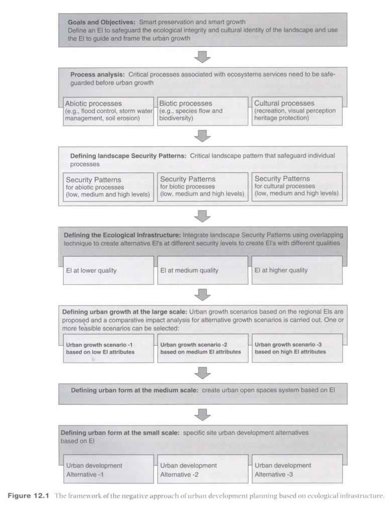
With these objectives in mind, the Negative Approach to planning is composed of the following steps:
2.1 Process analysis
Processes associated with critical ecosystems’ functions or services are targeted to be safeguarded by EI; thus systematic analysis shall be carried out using Geographical Information Systems (GIS), which are an efficient tool to simulate natural and cultural processes across the landscape. These processes include:
(1) Abiotic processes, associated with the regulation and life supporting services of ecosystems;
(2) Biotic processes, associated with life support services of ecosystems in providing habitat (suitable living space) for native wild plant and animal species and biodiversity conservation.
(3) Cultural processes, associated with information functions including visual perception, heritage protection and recreational activities.
2.2 Defining Landscape Security Patterns
Landscape Security Patterns (SPs) are identified for the individually targeted processes. SPs are composed of elements and spatial positions that are strategically important in safeguarding the different processes across the landscape. Models including suitability analysis, minimum cost distance and surface analysis were used in the identification of Security Patterns for the individual processes (Yu 1995, 1996). Alternative security levels - low, medium and high - are used to define the attributes of the SPs in safeguarding each of the targeted processes.
2.3 Defining Ecological Infrastructure
The overlaying technique is used to integrate the SPs for individual processes. Alternatives of EI are developed at various quality levels: high, medium and low. Green lines were drawn to define and protect the EI.
The EI is planned at three scales:
(1) The regional scale (hundreds to thousands of square kilometers): at the regional scale green lines are drawn to define the structural elements as corridors and restricted areas for construction.
(2) The intermediate scale (tens of square kilometers): at this scale the overall design and management guidelines are developed for EI, and especially for the green corridors that work as critical EI elements in water management, biodiversity conservation, heritage protection and recreation.
(3) The small scale (less than ten square kilometers): at a specific site an urban green network is designed to allow ecosystem services to be delivered into the urban fabric.
2.4 Defining urban form at the large scale: urban growth alternatives based on regional EI
Urban development patterns are defined at regional scales based on regional EI. Using the multiple EI alternatives as framing structures, scenarios of regional urban growth patterns are developed. A planning committee, represented by decision makers of the city, planning experts and stakeholders, makes impact assessment for these scenarios. The decision makers, can finally select one of the scenarios based on a balanced evaluation of economic, ecological and social benefits.
2.5 Defining urban form at the intermediate scale: urban open spaces system based on EI
At the intermediate scale the regional EI is to be integrated inside the urban structure and become the urban greenspace system, which integrates various functions of ecological conservation, heritage protection and recreational activities, commuting and cycling.
2.6 Defining urban form at the small scale: site specific urban development alternatives based on EI
Alternative urban development models are designed at an individual site and neighborhood, following EI guidelines developed above for the site,. In these urban development alternatives, ecosystem services safeguarded by EI are delivered into the urban fabric so that the conventional urban sprawl can be avoided. Building the EI into the site specific land use schemes, as a new way of development, will not only help the whole city, but will also benefit the site specific development ecologically and economically (Figure 01).
3 Urban Growth Based on EI: a Case of Negative Planning for Taizhou City
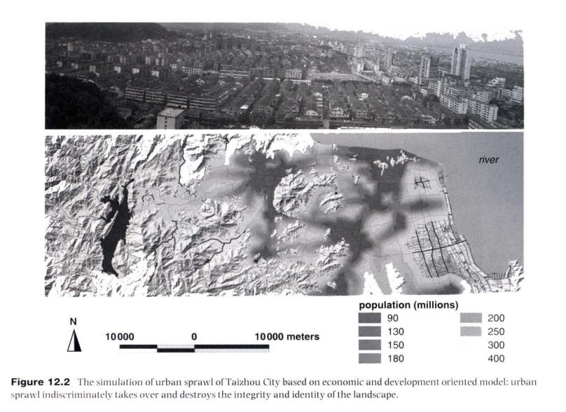
Taizhou is located on the South East coast of China, with a total area of 9,411 square kilometers and a population of 5.5 million. Out of the population, only 0.7 million live in urban areas; the urban population is expected to increase to 0.9 million in 2010, 1.3 million in 2020, and 1.5 million in 2030. Although it has quite a rural and agricultural character, it is now one of the fastest growing areas in China due to a boom of small private industries (Figure 02).
Under the influence of the monsoon climate and being adjacent to the sea, flooding has been a major hazard. As an adaptation to the storm water and flood problem, the landscape has been shaped into a unique form featuring a network of water courses that integrate natural water systems, wetlands and man made ditches, as well as cultural heritage features such as bridges, dikes, dams, and vernacular landscapes. This area has long been famous for its rice, fishery and citrus production. Arable and land plains available for development are very limited in this area.
This water network landscape, which has been effective in preserving the agricultural processes for thousands of years, is now facing the challenge of being destroyed by the swift urbanization process that began in the early 1990s. The wetlands have been filled, rivers have been straightened and channeled, cultural heritage features (not listed as protected historical relics), have been destroyed and visual and recreational experiences have been totally ignored.
Addressing the above situations, the Negative Approach to urban growth planning was taken to safeguard sustainability of the landscape.
3.1. Critical Landscape Processes
Three categories of processes are targeted:
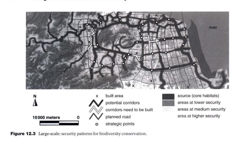
(1) The abiotic processes: in Taizhou area the monsoon storms frequently cause floods and waterlogging, so the main focus of the process analysis is flood control and storm water management (Figure 03).
(2) Biotic processes: native biodiversity conservation is the focus of the biotic analysis. Birds are the main concern for this area due to the rich fluvial and inter-tidal wetland ecosystems. This area has been listed as one of the important bird areas, both nationally and globally. Feeding, nesting and immigration processes are the main focus for the purpose of the protection of habitats and biodiversity (Figure 04,05).
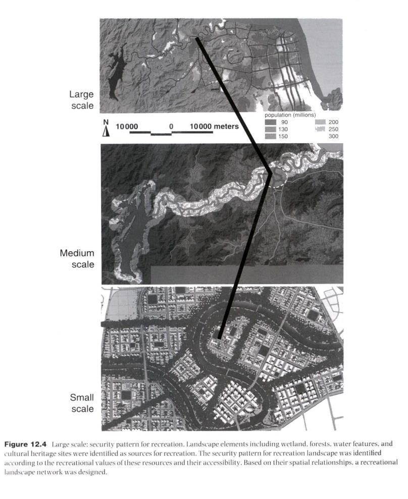
(3) Cultural processes: the targeted cultural processes include historical processes of cultural heritage sites and the cultural landscape and the process of recreational use of the landscape. (Figure 06,07)
Arc/Info GIS was used to store, overlay and analyze layers of natural, cultural and social economic data.
3.2 Defining Landscape Security Patterns for the Targeted Processes
Borrowing the security pattern model from biological conservation, the general spatial model for the SPs for all the horizontal processes across the landscape are composed of the following elements (Yu 1996).
Sources: the core area and the origin of the of the target process, such as core habitats for the targeted species, heritage sites for preservation and fishing ponds for recreation.
Buffer zones: the areas around the sources, which are potentially important for protecting the sources.
Linkages: the connecting linear elements that link two or more of the sources.
Radiating routes (for biological processes): from the sources, which are the potential network for species to take control of the landscape. Here, the target species are taken as active and initiating forces of control over the landscape.
Strategic points: the spatial location that potentially controls the movement and connectivity of the target process.
SPs for any individual process are composed of more than one of the elements, but not necessary all of them:
Three security levels - low, medium and high - are used to define the quality of the SPs in safeguarding each of the targeted processes. The security levels are classified according to the area, number and quality of the landscape elements that make up the Security Patterns.
(1)Security Patterns for floods
Various hydrological models are used to simulate floods based on rainfalls, tides, terrain and wetlands. Floodable areas are calculated for 10 years, 20 years and 100 years frequencies, which are used as the criteria for the definition of security level of floods. Flood SPs include the existing water channel network, wetland, and potential wetlands and flood vulnerable areas. (Figure 03)
(2) Security Patterns for biodiversity conservation
The Focal Species Approach for biodiversity conservation is widely accepted and used to identify critical landscape elements and locations of biodiversity conservation (Caro 2000, Opdam, Verboom, et al. 2003, Brooks and Kennedy 2004, Lambeck 1997, Eycott, Watts et al. 2007). Birds are the main concern for this area due to the rich fluvial and inter-tide wetland ecosystems. Nationally ranked endangered birds (in the red list) are selected as the focal species to identify native habitats and biodiversity protection.
The Security Patterns are identified based on two overlaid analysis (Yu 1996): the suitability analysis of the habitats (sources) for the focal species, and the potential surface analysis based on the least-cost analysis and surface models (Knaapen et al. 1992, Yu 1995, 1996, 1998, Ferreras 2001, Graham 2001, Michels et al. 2001, Schadt et al. 2002, Adriaensen 2003). On the potential surface, buffer zones, potential linkages, radiating routes and strategic points were able to be identified. (Figure 04,05)
(3) Security Patterns for the cultural processes
Both heritage sites and linkages that connect, or potentially connect, these sites are included in the construction of SPs for heritage protection. Recreational sources are then referred to (e.g. water body for fishing, forest for hiking, and historical site for sightseeing) and the linkages between these resources are based on the least-distance model result. (Figure 06,07)
3.3 Defining Ecological Infrastructure
The overlaying technique is used to integrate the SPs for individual processes. Alternatives of EI are developed at various quality levels: high, medium and low. Green lines were drawn to define and protect the EI.
The EI is planned at three scales (Figure 08, 09):
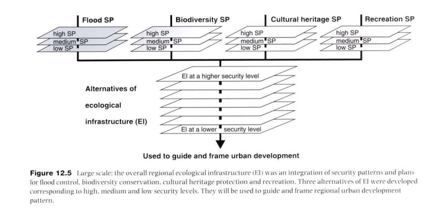
(1) The regional scale (hundreds to thousands of square kilometers): at the regional scale green lines are drawn to define the structural elements as corridors and restricted areas for construction. Alternatives of regional EI are developed at diverse quality levels: high, medium and low.
(2) The intermediate scale (tens of square kilometers): at this scale, the overall design and management guidelines are developed for EI, and especially for the green corridors that work as critical EI elements in water management, biodiversity conservation, heritage protection and recreation.
(3) The small scale (less than ten square kilometers): at a specific site an urban green network is designed to allow ecosystem services to be delivered into the urban fabric.
3.4. Scenarios Of Urban Growth Pattern Based On The Regional Ecological Infrastructure
Using the three regional EI alternatives as a framework structure, scenarios of regional urban growth patterns were simulated using GIS: the Adjusted Sprawl scenario, the Aggregated scenario, and the Scattered scenario (Figures 10, 11,12).
Comparative impact evaluations were made for these scenarios by a planning committee composed of decision makers of the city, planning experts from all over the country, and stakeholders -who are represented by officials from various functional departments of the Taizhou city government- (including the departments of agriculture, water management, forestry, industry, tourism, finance, transportation, public affairs, security, culture education, tax, etc.). It also includes representatives of individual villages who originally owned the land as well as representatives of developers and representatives of investors who are eager to get the right to develop the land.
Decision makers finally selected one of the three urban growth scenarios as the most feasible, after multiple brainstorming sessions among the planning committee. As expected, the Aggregated Scenario, which is based on the medium quality EI, was considered the more balanced and less difficult to be implemented.
3.5. Shaping urban form at the intermediate scale
In shaping the urban form and structure at the city scale, an urban open space system is planned connecting the regional EI with the inner city’s landscape elements, related to ecological, cultural and recreational values, and also integrated with the commuter routes, cycling network and pedestrian network. (Figure 13)
3.6. Shaping urban land development at the small scale
Using a selected site (ten square kilometers in size) as a demonstration, alternative urban development models were designed to test the possibility of building an EI based city. In these alternatives, ecosystem services safeguarded by EI are delivered into the urban fabric so that the conventional urban development model can be avoided (Figure 14,15,16).
These new urban land development alternatives were presented to the developers and investors, as well as to the city’s decision makers, to let them know that the business-as-usual models of land development can be avoided. The new way of development, by building the EI into their land use scheme, will not only help the whole city, but will also benefit site development ecologically and economically. These alternative development schemes show how the regional, large and small scales of EI can be realized in land development to handle the problem of urban growth.
4. Conclusion
It is argued that the current urban growth model in China is unsustainable. Recognizing this fact the Chinese leadership is now calling for Ecological Civilization (Hu Jingtao 2007), a totally new concept proposed in the Chinese language and especially worded by the top Chinese leader. It reflects an important change in the top Chinese leadership’s understanding of development. Rather than emphasizing economic construction as the core of development as it did in the past, the Chinese leadership has come to realize that development, if sustainable, must entail a list of elements including the right relationship between man and nature. The ecological civilization concept is proposed at a time when ecological and environmental issues are at a very serious stage. Facing such a reality, the construction of Ecological Civilization was definitely not rhetoric for self adulation by officials in their speeches. It needs to be transformed into tangible measures that will change the way our economy develops and reshape the landscape to be able to meet the serious challenges of sustainable development.
Accordingly, it is important to recognize that the conventional approach to urban development planning, which is based on population projection and then built-infrastructure, is unable to meet the challenges and needs of ecological and sustainable urban development, and is certainly unable to meet the goal of Ecological Civilization. It is in this situation that the Negative Approach is proposed. Using the analogy of photography in describing the film and picture, the term “Negative” is used to describe the urban development model being negatively en-framed by Ecological Infrastructure, not the other way around. To put it another way, the EI is positively defining the urban form and growth pattern. Conventionally, landscape and green elements such as greenbelt and green heart are usually negatively defined by architectural and built infrastructure. By positively defining the EI for the sake of Natural Capital and cultural integrity of the land, the urban growth pattern and urban form are negatively defined. The Negative Approach, and especially the concept of Ecological Infrastructure, build a bridge between landscape urbanism, the disciplines of ecology and especially landscape ecology, the notion of Natural Capital and ecosystems services, and sustainable development. It is a bridge between smart growth and smart conservation.
References
Adriaensen, F., Chardon, J.P., De Blust, G., Swinnen, E., Villalba, S., Gulinck, d. H., Matthysen, E. (2003) The application of ‘least-cost’ modelling as a functional landscape model. Landscape and Urban Planning 64, 233–247.
Ahern, J. (1985) Greenways as a planning strategy. Landscape and Urban Planning 33, 131-155.
Ahern, J. (1991) Planning and design for an extensive open space system: linking landscape structure to function. Landscape and Urban Planning 21, 131-145.
Ahern, J. (2007) Green infrastructure for cities: The spatial dimension. In: Novotny V., Brown P. (eds.) Cities of the Future. Towards Integrated Sustainable Water and Landscape Management. IWA Publishing, London, UK. pp.
Ahern, J. (2002) Greenways as Strategic Landscape Planning: Theory and Application. Wageningen University, The Netherlands.
ASLA (2005) The Announcement of 2005 ASLA Professional Awards. http://www.asla.org/awards/2005/05winners/entry_075.html. Accessed....
Benedict M., McMahon E. (2006) Green Infrastructure: Linking Landscapes and Communities. Island Press. Washington, USA.
Bishoff, N.T., Jongman R. (1993) Development of Rural Landscape. USDI National Park Service. Washington DC. 148pp.
Blumenfeld, H. (1949) Theory of city form, past and present. Journal of the Society of. Architectural Historians 8, 7–16.
Bohemen, H. (2002) Infrastructure, ecology and art. Landscape and Urban Planning 59, 187-201.
Brooks, T., Kennedy, E. (2004) Conservation biology: Biodiversity barometers. Nature 431, 1046-1047.
Buuren, M. van, Kerkstra, K. (1993) The framework concept and hydrological landscape structure: a new perspective I the design of multifunctional landscape. In: Vos C.C., Opdam P. (eds.) Landscape ecology of a stressed environment. Chapman & Hall, London, pp. 219-243.
Caro, T. (2000) Focal species. Conservation Biology 14 (6), 1569–70.
Chen, K., Lü Yong, Z., Hang, Xiaohong (2004) No water without wetland. China Environment and Development Review, 296-309. Social Sciences Documentation Publishing House.
Cook, E., van Lier, H. (1994) Landscape planning and ecological networks. Netherlands. Elsevier Science B.V.
Corner, J. (1999) Recovering Landscape as a Critical Cultural Practice. In: Corner, J. (ed.) Recovering Landscape: Essays in Contemporary Landscape Architecture. Princeton Architectural Press.
Corner, J. (2006) Terra fluxus. In: Wadheim, C. (ed.) Landscape Urbanism. Princeton Architectural Press.
Costanza R., Daily H.E. (1992) Natural capital and sustainable development. Conservation Biology 6, 37-46.
Costanza, R. et. al. (1997) The Value of the World’s Ecosystem Services and Natural Capital. Nature 387, 253-259.
Daily, G..C. (2000) Management objectives for the protection of ecosystem services. Environmental Science and Policy 3, 333-339.
Daily, G..C., Söderqvist, T., Aniyar, S., Arrow, K., Dasgupta, P., Ehrlich, P.R., Folke, C., Jansson, A., Jansson, B., Kautsky, N., Levin, S., Lubchenco, J., Mäler, K., Simpson, D., Starrett, D., Tilman, D., Walker, B. (2000) The value of nature and the nature of value. Science 289, 395-396.
Daily, G. C. (1997) Nature’s Services: Society Dependence on Natural Ecosystems. Island Press, Washington, D.C.
De Groot, R.S. (2006) Function analysis and valuation as a tool to assess land use conflicts in planning for sustainable, multi-functional landscapes. Landscape and Urban Planning 75 (3–4), 175–186.
De Groot, R.S., Wilson, M.A., Boumans, R.J., (2002) A typology for description, classification and valuation of ecosystem functions, goods and services. Ecol. Econ. 43(3), 393–401.
Eycott, A ., Watts, K., Moseley, D., Ray, D. (2007) Evaluating Biodiversity in Fragmented Landscapes:The Use of Focal Species, Forestry Commission, October, 2007, Edinburgh, U.K.
Fabos, J. G. (1995) Introduction and overview: the greenway movement, uses and potential of greenways. Landscape and Urban Planning 33, 1-13.
Fabos, J.G. (2004) Greenway planning in the United States: its origins and recent case studies. Landscape and Urban Planning 68, 321-342.
Fedorowick, J.M. (1993) A landscape restoration framework for wildlife and agriculture in the rural landscape. Landscape and Urban Plannning 27, 7-17.
Ferreras, P. (2001) Landscape structure and asymmetrical inter-patch connectivity in a metapopulation of the endangered Iberian lynx. Biological Conservation 100, 125–136.
Forman, R., Collinge, S. (1997) Nature conserved in changing landscapes with and without spatial planning. Landscape and Urban Planning 37, 129–135.
Forman, R. (1995) Land Mosaics: The Ecology of Landscapes and Regions. Cambridge University Press, Cambridge, UK.
Forman, R., Godron, M. (1986) Landscape Ecology. John Wiley and Sons, Inc., New York, NY, USA.
Frey, H.W. (2000) Not green belts but green wedges: the precarious relationship between city and country. Urban Design International 5 (1), 13–25.
Gao Jixi, Zhang Xianghui, Jiang Yun, Ou Xiaokun, He Daming and Shi JianBin, 2007, Key issues on watershed ecological security assessment. Chinese Science Bulletin 52(2), 251-261.
Gaubatz, P. (1999) China’s urban transformation: patterns and process of morphological change in Beijing, Shanghai and Guangzhou, Shanghai and Guangzhou. Urban Studies 36(9),1495–1521.
Graham, C.H. (2001) Factors influencing movement patterns of keel-billed toucans in a fragmented tropical landscape in southern Mexico. Conservation Biology 15, 1789–1798.
Guo Ming, Li Xin, Xiao Duning (2005) Ecological security pattern analysis of Jiuquan oasis using remote sensing and GIS. Geoscience and Remote Sensing Symposium. IGARSS '05. Proceedings. 2005 IEEE International, 25-29 July 2005, pp.1867- 1870
Guo Xiaomin ( date? ) The economic cost of environmental pollution and ecological deterioration. China Environment and Development Review, 53-71. Social Sciences Documentation Publishing House.
Haines-Young, R. (2000) Sustainable development and sustainable landscapes: defining a new paradigm for Landscape Ecology. Fennia 178(1), 7–14.
Honachefsky, W. B. (1999) Ecologically Based Municipal Planning [M]. Lewis Publisher. Boca Raton, FL.
Howard, E. (1946) Garden Cities of Tomorrow. Faber & Faber, London (first published 1898).
Hu Jintao (2007) Report to the Seventeenth National Congress of the Communist Party of China on October 15, 2007. City?/ Publisher?
Jiang Gaoming, Liu Meizhen (2004) Sand Storm, China Environment And Development Review, 2,310-322. Social Sciences Documentation Publishing House.
Jianquan Cheng, Masser, I. (date) Urban growth pattern modeling: a case study of Wuhan city, PR China. Landscape and Urban Planning 62, 199–217.
Jim, C.Y., Chen, S. (2003) Comprehensive greenspace planning based on landscape ecology principles in compact Nanjing city, China. Landscape and Urban Planning 65, 95–116.
Jongman, R. H. (2001) The context and concept of ecological networks. In:Rob. H. G., Jongman, R.H., Pungetti, G. (eds.) Ecological Networks and Greenways: Concept, Design, Implementation. Cambridge University Press, pp.7-33.
Jongman, R.H.G. (1995) Nature conservation planning in Europe: developing ecological networks. Landscape and urban planning 32, 169-183.
Huang Junfang , Wang Ranghui , Zhang Huizhi (2007) Analysis of patterns and ecological security trend of modern oasis landscapes in Xinjiang, China. Environmental Monitoring and Assessment 134(1-3), 411-419.
Kerkastra, K., Vrijlandt, P. (1990) Landscape planning for industrial agriculture: a proposed framework for rural area. Landscape and urban planning 18:(3-4), 275-287.
Knaapen, J.P., Scheffer, M., Harms, B. (1992) Estimating habitat isolation in landscape planning. Landscape and Urban Planning 23, 1016.
Lambeck, R.J. (1997) Focal species: A multi-species umbrella for nature conservation. Conservation Biology 11 (4), 849–56.
Lip, E. (1979) Chinese Geomancy. Times Book International, Singapore.
Little, C. (1990) Greenways for America. John Hopkins University Press, Baltimore, MD.
Liu Shi-rong, Lin Yong, Sun Peng-sen, Li Chong-wei, Hu Yu-zhe (2006) Forest landscape ecology and its applications in China. Forestry Studies in China 8(1), 53-58. Beijing Forestry University, co-published with Springer-Verlag GmbH.
Lumenfeld, H. (1949) Theory of city form, past and present. Journal of the Society of Architectural Historians 8, 7–16.
Mander, U.E., Jagonaegi, J. and Kuelvik, M. (1988) Network of compensative areas as an ecological infrastructure of territories. In: Schrieiber, K.-F. (ed.), Connectivity in Landscape Ecology, Proceedings of the 2nd International Seminar of the International Association for Landscape Ecology. Ferdinand Schoningh. Paderborn, pp. 35-38.
Mao Qizhi (2003) Green Space of Beijing City: History and Prospect. Beijing City Planning & Construction Review, supplementary issue, 137-138.
Amati, M., Makoto Yokohari (2006) Temporal changes and local variations in the functions of London’s green belt. Landscape and Urban Planning 75, 125–142.
McHarg, I.L. (1969) (l992 edition) Design With Nature. John Wiley & Sons, Inc.
Michels, E., Cottenie, K., Neys, L., De Gelas, K., Coppin, P., De Meester, L., (2001) Geographical and genetic distances among zooplankton populations in a set of interconnected ponds: a plea for using GIS modelling of the effective geographical distance. Molecular Ecology 10, 1929–1938.
Millennium Ecosystem Assessment (MEA). (2005) Ecosystems and Human Well-Being: Synthesis. Island Press, Washington. 155pp.
Min Xiying, Yang Baojun (2003) The Second Green Belt and Beijing Spatial Distribution. City Planning Review 9, 17-21.(In Chinese)
Moughtin, C. (1996) Urban Design: Green Dimensions. Butterworth Architecture, Oxford. Mountains. Landscape Ecology 15, 713–730.
Naveh, Z., Lieberman, A. (1984) Landscape ecology: theory and application. Springer-Verlag, New York, USA.
Noss, R., Harris, L.D. (1986). Nodes, networks, and MUMs: Preserving diversity at all scales. Environmental Management 10(3), 299-309.
Noss, R. (1993) Wildlife corridors. In: Smith, D.S., Hellmund, P.C. (eds.)
Opdam, P., Verboom, J., Pouwels, R. (2003) Landscape cohesion: an index for the conservation potential of landscapes for biodiversity. Landscape Ecology 18 (2), 113–26.
Ouyang Zhiyun (2003) The ecological planning of Beijing green belt. Beijing City Planning & Construction Review, supplementary issue, 202-205. (In Chinese)
Potschin, M., Haines-Young, R. (2006) “Rio+10”, sustainability science and Landscape Ecology. Landscape and Urban Planning 75, 162–174.
Rossbach, S. (1983) Feng-shui: the Chinese Art of Placement. E.P Dutton, Inc.
Schadt, S., Knauer, F., Kaczensky, P., Revilla, E., Wiegand, T., Trepl, L., (2002) Rule-based assessment of suitable habitat and patch connectivity for Eurasian Lynx in Germany. Ecol. Appl. 12, 1469–1483.
Seans, R.M. (1995) The evolution of greenways as an adaptive urban landscape form. Landscape and Urban Planning 33, 65-80.
Selm, A,J. Van. (1988) Ecological infrastructure: a conceptual framework for designing habitat networks. In: Schreiber, K.-F. (ed.) Connectivity in Landscape Ecology, Proceedings of the 2nd International Seminar of the International Association for Landscape Ecology. Ferdinand Schoningh. Paderborn, pp.63-66.
Skinner, S, (1982) The Living Earth Manual of Feng-shui. Routledge & Kegan Paul. London.
Taylor, L. (1978) Urban Open Spaces. Academy Editions, London.
Toft, D. (1995) Green belt and the urban fringe. Built Environment 21 (1), 54–59.
Troll, C. (1939) Luftbildplan und ökologische Bodenforschung (Aerial photography and ecological studies of the earth). Zeitschrift der Gesellschaft für Erdkunde, Berlin, 241-298.
Turner, M.G. (1989) Landscape ecology: the effect of pattern on process. Annual Review of Ecology and Systematics 20, 171-197.
Turner, M.G., Gardner R. H.,O'Neill, R. V. (2001) Landscape Ecology in Theory and Practice. Springer-Verlag, New York, NY, USA.
United Nations (UN) (2007) State of World Population - Online Report: United Nations Population Fund.
Villalba, S., Gulinck, H., Verbeylen, G., Matthysen, E. (1998) Relationschip between patch connectivity and the occurence of the European red squirrel, Sciurus vulgaris, in forest fragments within heterogeneuos landscapes. In: Dover, J.W., Bunce, R.G.H. (eds.) Key Concepts in Landscape Ecology. Preston, pp. 205–220.
Wadheim, C. (ed.) (2006) Landscape Urbanism. Princeton Architectural Press.
Walmsley, A. (1995) Greenways and the making of urban form. Landscape and Urban Planning 33, 81-27
Walmsley, A. (2006) Greenways: multiplying and diversifying in the 21st century. Landscape and Urban Planning 76, 252–290.
Wang Jun (2003) Cheng Ji. Sanlian Shudian Publisher. (In Chinese)
Wascher, D.M. (2000)p. 7, Wascher, D.M. (ed.) Proceedings of European Workshop on Landscape Assessment as a Policy Tool. European Centre for Nature Conservation and The Countryside Agency, Tilburg, Cheltenham, p. 92
Wilson, O., Edward. (1992) The Diversity of Life. The Belknap Press of Harvard University Press, Cambridge, MA.
Wu Liangyong, Wu Tinghai (2003) From strategic plan to action plan. City Planning Review 12, 13-17. (In Chinese with English abstract)
Yang Baojun (2003) An approach to reform confronting the reality: on the theoretical and practical implication of immediate planning. City Planning Review 3, 5-9. (In Chinese)
Yeh, A.G., Wu, F. (1999) The transformation of the urban planning system in China from a centrally-planned to transitional economy. Prog. Plann. 51(3), 167–249.
Yokohari, Makoto, Takeuchi, Takeuchi, Watanable, Takashi, Yokota, Shigehiro (2000) Beyond greenbelts and zoning: A new planning concept for the environment of Asian mega-cities. Landscape and Urban Planning 47, 159-171.
Yu Kongjian (1996) Security patterns and surface model in landscape planning. Landscape and Urban Planning 36(5), 1-17.
Yu Kongjian (1998) Landscape ecological security patterns in biological conservation. Acta Ecologica Sinica 19(1), 8-15. (In Chinese with English abstract)
Yu Kongjian (1994) Landscape into places: Feng-shui model of place making and some cross-cultural comparison. In: Clark, J. D. (ed.) History and Culture. Mississipi State University, USA. pp.320-340.
Yu Kongjian, Li Dihua,,Liu Hailong Han Xili (2005a) On the "Negative Planning". City Planning Review 9, 64-69.(In Chinese with English abstract)
Yu Kongjian, Li Dihua, Liu Hailong, Han Xili (2005b) Growth Pattern of Taizhou City Based on Ecological Infrastructure- A Negative Approach Physical Urban Planning. City Planning Review 9, 76-80. (In Chinese with English abstract)
Yu Kongjian, Padua, M. (2006) The Art of Survival. The Images Publishing Group, Victoria, Australia
Zhang, Bing (2003) My view on the immediate plan. City Planning Review 6, 64-65. (In Chinese)
Zhao Jingxing Huang Ping Yang Chaofei Guo Xiaomin (2004) Situation of China’s Environment and development. China Environment and Development Review 2, 23-50. Social Sciences Documentation Publishing House.
Zhao, Yanqing (2004) Rapid development and spatial extension: a case study of Shenzhen. City Planning Review 6, 32-42. (In Chinese)
Zube, E. (1995) Greenways and the US National park system. Landscape and Urban Planning 33, 17-25.
Zube, E.H. (1986) The advance of ecology. Landscape Architecture 76(2), 58-67.
