模式化景观途径营造低维护海绵城市: 泰国曼谷班加科特森林公园
- 摘要:
- 在泰国曼谷繁华的城市中心地带,设计团队将一个前烟草工厂转变成了一座活力四射的新文化地标——班加科特森林公园。项目之初,设计团队面临场地上洪涝和干旱交替发生、北侧运河水体污染严重、可达性差、建设资金有限、工期紧张(仅18个月)等多重挑战。通过生态修复手段,设计将场地转变为了可提供全面生态系统服务且富有韧性的生态系统:设计后的公园可以拦截瞬时暴雨积洪并降低其破坏力、净化被污染的水体、调节旱涝,以及为野生动物提供亟需的栖息地。班加科特森林公园不仅成为了曼谷市中心及其周边地区最大的公共游憩空间,也为其他类似城市公共绿地设计实践提供了一种可借鉴的低维护、模式化途径。 In the bustling heart of Bangkok, Thailand, the design team transformed a former tobacco factory into a vibrant new cultural landmark—Benjakitti Forest Park. The project faced a number of challenges including seasonal floods and droughts on the site, severe water pollution in the surroundings, poor accessibility, limited construction funds, and a compressed timeframe (only 18 months). The design has restored the site into an urban park with a resilient ecosystem that intercepts and reduces the destructive force of stormwater, filters contaminated water, and provides much-needed wildlife habitat. Benjakitti Forest Park has not only become the largest public recreational venue for residents of downtown Bangkok and its environs, but also offers a low-maintenance, modular approach for worldwide urban public green space design practice.
文章来源:俞孔坚, & 王冬. (2023). 模式化景观途径营造低维护海绵城市:泰国曼谷班加科特森林公园. 景观设计学(中英文) 11(1), pp.72-85.
1 项目背景
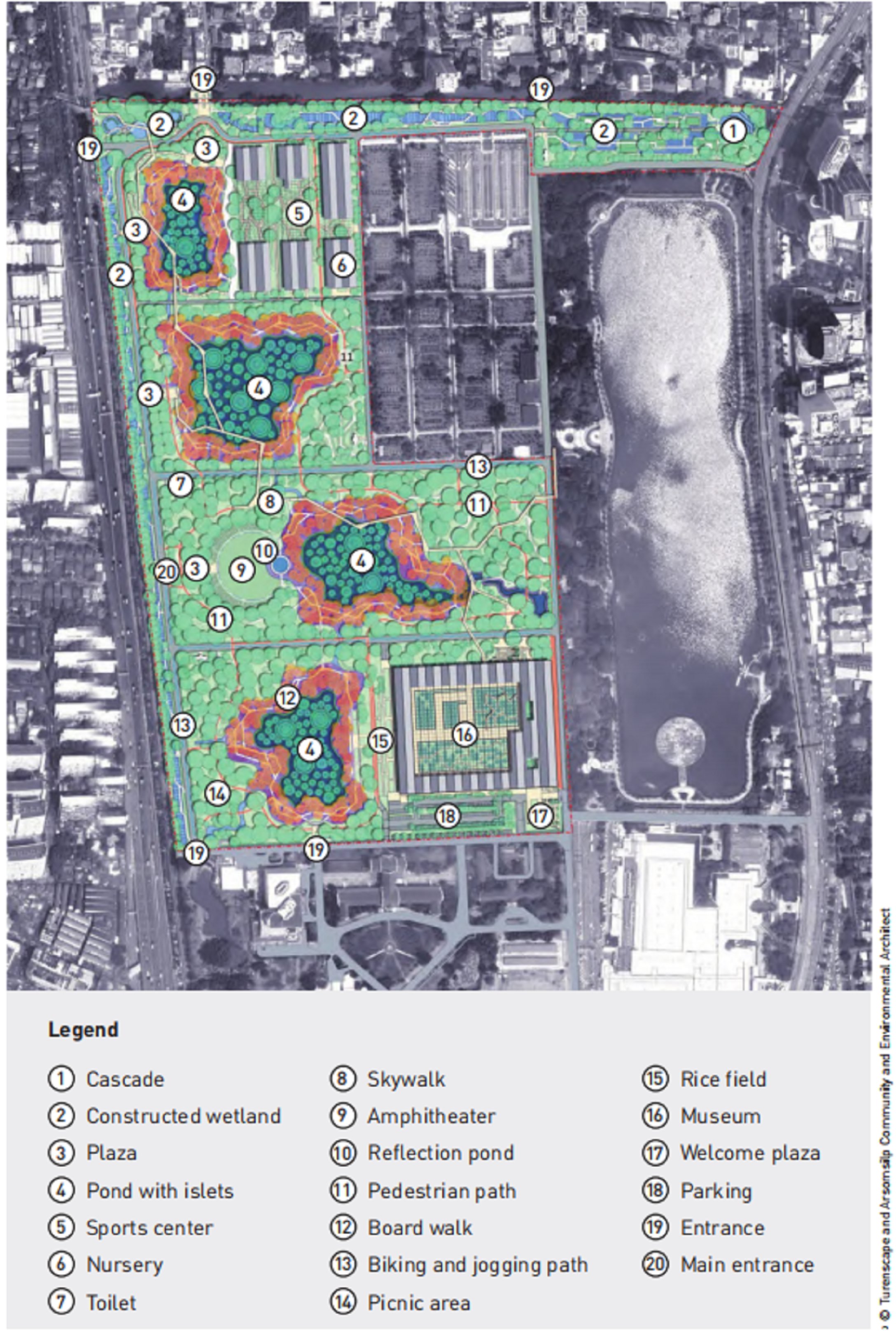
项目场地位于泰国曼谷市中心孔堤区,为泰国财政部所属烟草局工厂的一部分。早在1991年12月,当地政府即批准了烟草工厂搬迁的决议,在腾退出的土地上建设了面积20.8hm2 的水公园(2004年)和9.8hm2的班加科特森林公园一期(2016年)。2019年,政府发起森林公园二期设计竞赛,并计划于2021年6月前完工,以庆祝泰国诗丽吉王太后九十岁寿辰;除明确要求保留的四栋建筑外(将改造为博物馆、体育中心等场馆),其余厂房均予以拆除。场地周围为高密度居住区,森林公园建成后将成为曼谷市中心最大的公共绿地,服务周边5km范围内约25万常住人口及曼谷庞大的旅游人群。竞赛共有六支国际(联合)设计团队参加,土人设计与泰国阿颂·信建筑事务所联合设计团队的设计方案最终胜出。
2 场地现状与挑战
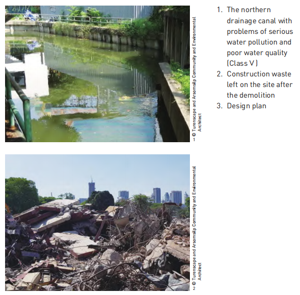
场地西侧的城市快速路将场地与周边社区割裂,东侧为一座人工湖,南部为医院、酒店和诗丽吉王后国家会议中心,北部曾经的城市运河现已成为排水渠,水质受城市污水直排和城市径流的影响富营养化严重,水体受到严重污染(图1)。
场地中共有乔木有91个品种、865株,以垂叶榕(Ficus benjamina)、菩提树(Ficus religiosa)、盾柱木(Peltophorum pterocarpum)、腊肠树(Cassia fistula)、酸豆(Tamarindus indica)、杧果(Mangifera indica)为主;胸径1m以上的乔木有49株。除场地东部及单层厂房间散布的一些林荫大树外,这些乔木主要分布于道路两侧,其中榕树发达的根系已经和部分道路融为一体。因此,如何保护这些树木并使其与场地未来功能
规划相契合,就成了摆在设计团队面前的一道难题。
此外,本项目的预算极为有限(上限为20美元/m2 ),同时在项目工期上要求10个月内建成——后因新型冠状病毒感染疫情,最终要求于18个月内建成。出于建设速度考虑,项目的实施主体确定为本地部队工程兵,因其缺乏景观类项目建设管理经验,需要采取易于施工的设计策略。另外,在本项目之前落成的森林公园一期维护成本较高,在消耗了大量水资源用于灌溉的情况下,树木长势依然堪忧,因此如何降低后续维护成本也成为了本项目的挑战之一。
3 设计目标和策略
湿地是重要的生命支持系统[3],并在防洪抗旱、保持水土、维护生物多样性及休闲旅游等方面发挥重要作用[4][5]。设计从景观生态学的角度出发,在充分尊重场地现状的前提下,营造一个基于“多孔”理念的、弹性的、水-岛交织的海绵湿地系统[6]。
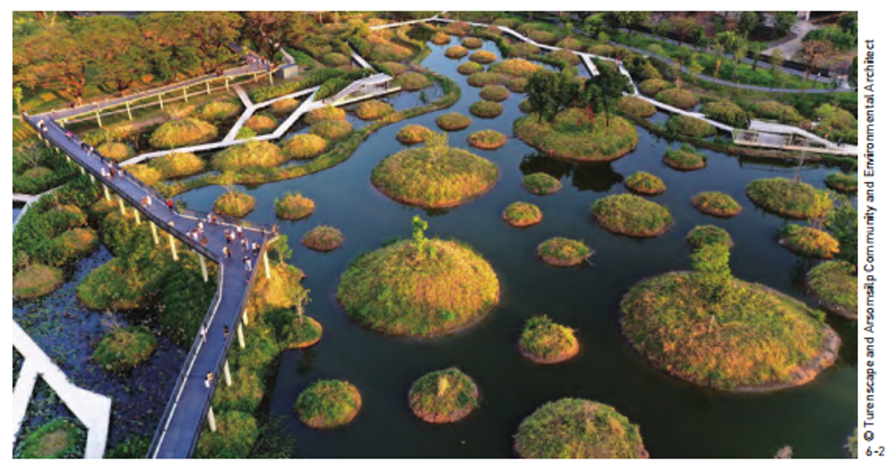
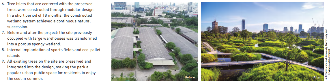
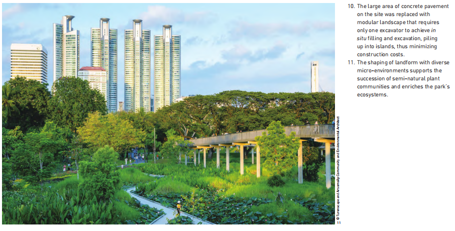
首先通过简单的挖填方技术,建造了4个散布着数百个小岛的湖区(即四大人工湿地),且每个湖都设计为两种不同的深度——较浅的梯级浅水带和较深的核心区域。为了实现对现有植被的最小干预,设计团队通过对场地所有乔木生长信息进行调查统计,选择占比最高的三个冠幅数值作为小岛直径设计参数——6m、12m、25m;然后以原有的树木作为每个岛屿的中心,构筑树岛(图6)。标准化便于施工,同时可将原本坚硬粘滞的表层土壤转变为海绵化生物栖息地(图7),以水作为媒介,疏通物质和能量交换;核心区水位变化提供调蓄空间的同时,可营造条件各异的多样化生境[3]。
湖区的梯级浅水带与沿公园北部和西部边缘修建的L型线性净化湿地相连,运河河水被引入湿地中并得到净化,每日净化水量可达8 152m3 。净化后的水体流经梯级浅水带汇入布满小岛的湖区中,依据“边缘效应”,这里的水质净化效率更高,并可促进这一水陆生境交错带物种多样性和种群密度的提升,包括促进钳嘴鹳(Anastomus oscitans)、小䴙䴘(Tachybaptus ruficollis)、大白鹭(Ardea alba)等重要湿地物种的活动强度和生产力。[7][8]
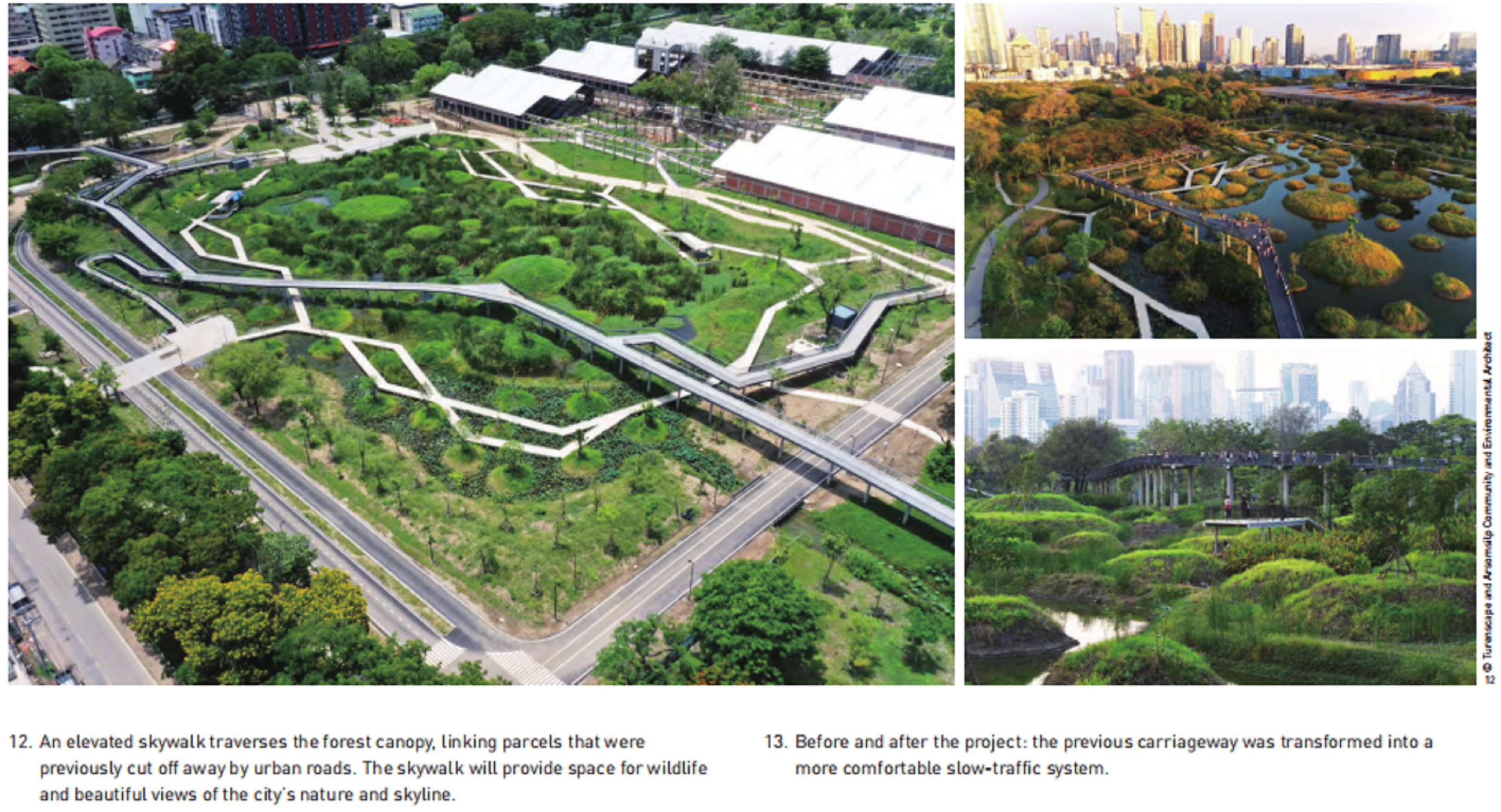
为提高公园的可达性、增强公园与周边社区及绿地的联系,项目设计了一条空中步道,将多年来被城市快速路分割的地块串联在一起。空中步道降低了对野生动物的干扰,也为游客提供了可以同时欣赏湿地“野性自然”及都市天际线的独特体验(图12)。
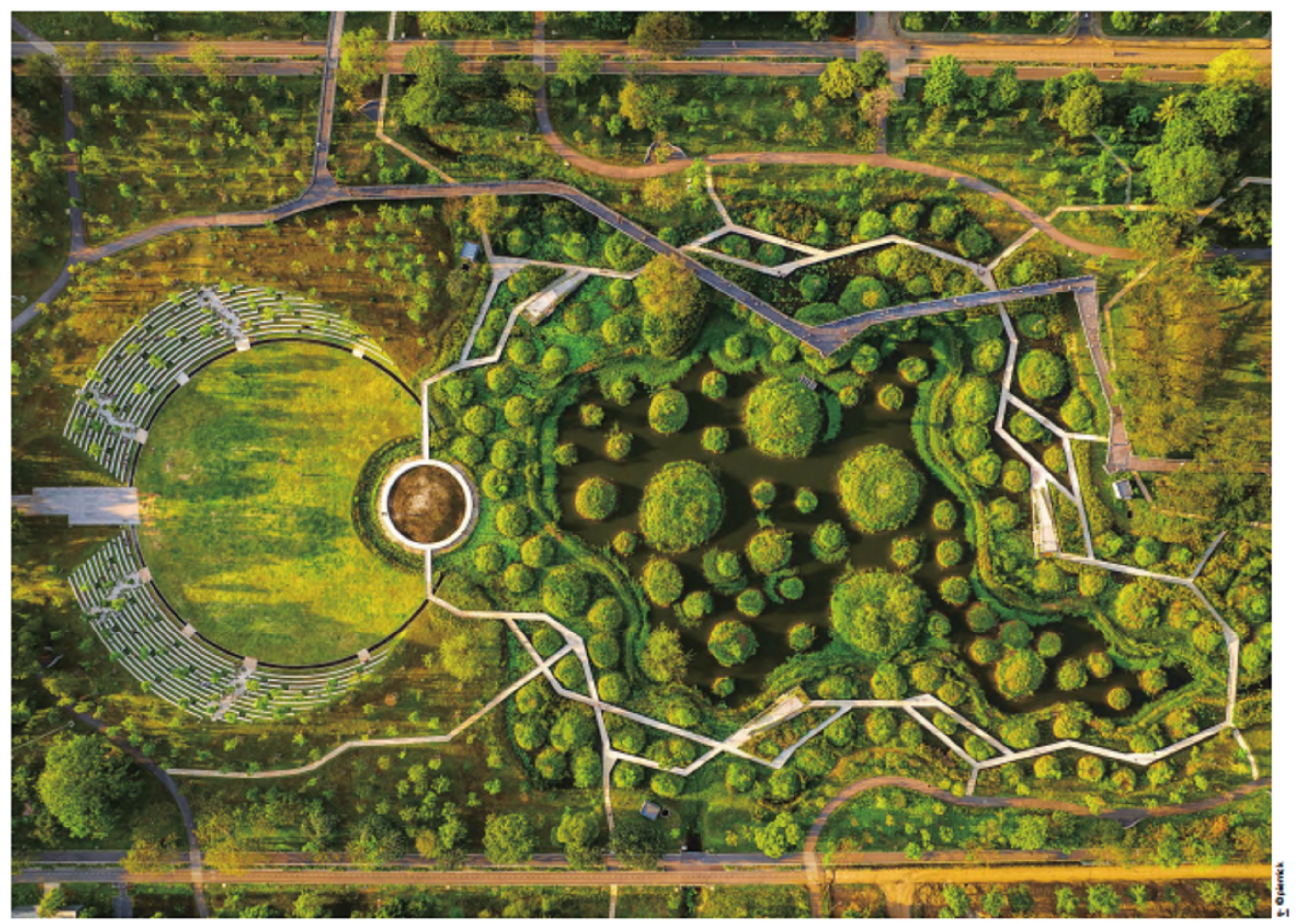
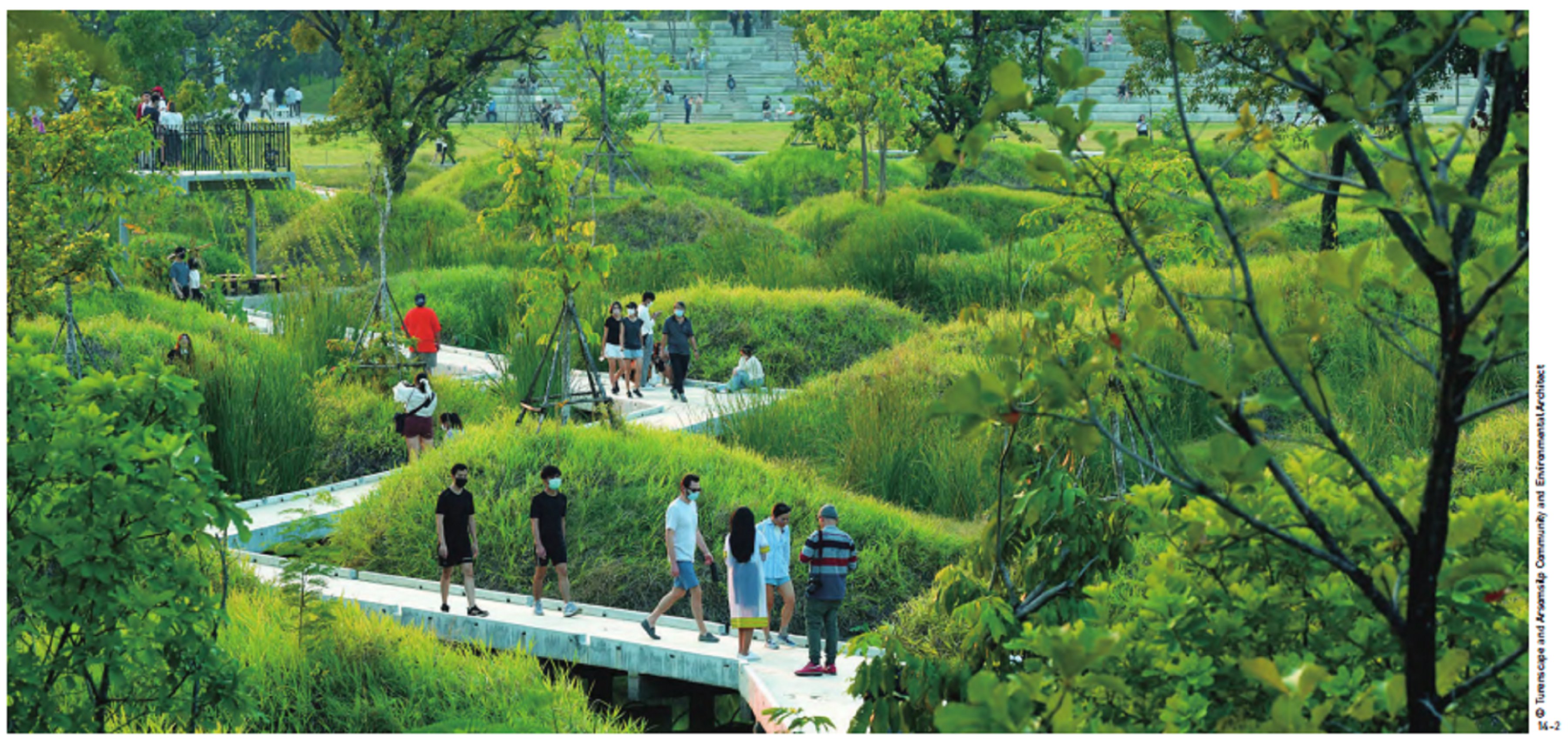
公园内部在保留和重新利用主要道路的同时,通过可渗透的生物滞留池和花圃,分隔自行车道与人行道,使原本为重型卡车设计的宽阔道路拥有更加宜人的尺度(图13)。沿着浅水湿地的边缘增设的多条相互交织的栈道可创造慢行的休闲体验,让游客沉浸式地感受人工湿地的自然景观(图14)。公园核心区域的大草坪和户外剧场(图15)、博物馆旁的水稻田(图16)、大量的林下空间等场所旨在创造多样活动的都市乐园,为曼谷市民及游客的各类公共生活提供舞台。
尽管班加科特森林公园二期面临各种严苛挑战,但事实证明,它的建造取得了巨大的成功。从生态系统服务的角度评估,公园满足了提供调节服务、供给服务、支持服务和文化服务的设计目标。2022年夏,曼谷再次经历了城市水患,公园及其附近地区并未受灾;水质净化湿地表现良好,如预期般地调蓄了足够的雨水,维系了湿地系统度过旱季,且市民可明显感受到公园的水体变得清澈、无异味。[10]此外,公园的生物多样性显著提升:自2022年5月至今,公园内已观察到鸟类近百种,数十种其他野生动物在此栖息觅食。作为曼谷市中心最大的城市公园,其所展现出的“野性自然”正在创造一种全新的、高度动态的、多样化的美学,与周围的都市景观形成鲜明对比(图17)。每天有数以万计的游客在园中进行慢跑、骑行、家庭聚会、学校庆典、野餐、艺术交流、约会和婚纱照摄影等活动。[10][11]公园已成为泰国首都的一处新地标,在社交媒体上广受欢迎。
Modular Approach Creating Low-Maintenance Sponge City: Benjakitti Forest Park in Bangkok, Thailand
1 Project Background
Located in Khlong Toei District, a central area in the City of Bangkok, Thailand, the project site was formerly a tobacco factory owned by the Ministry of Finance of Thailand. As early as December 1991, the local government approved the relocation of the tobacco factory, and started construction projects of a 20.8 hm2 water park (built in 2004) and the 9.8 hm2Benjakitti Forest Park Phase I (built in 2016) on the vacated land. In 2019, the government launched a design competition for Benjakitti Forest Park Phase II, which was scheduled to be completed by June 2021 to celebrate the 90th birthday of Thailand’s Queen Sirikit. The site is surrounded by high-density residential areas, and the Forest Park was envisioned as the largest public green space in the center of Bangkok, serving about 250,000 local residents in the surrounding neighborhoods and thousands of tourists. A total of six international (joint) design teams were invited, and the proposal by the joint design team of Turenscape and Arsomsilp Community and Environmental Architect won the competition.
2 Site Conditions and Challenges
Sitting in the Chao Phraya River Delta, Bangkok is a densely populated city with more than 10.5 million residents [1]. The region experiences a monsoon climate with an average precipitation of about 1,500 mm per year. Most of the area of the city was originally swampland, which was gradually drained with canals and extensive groundwater pumping for agriculture irrigation; at the same time, the over-extraction of groundwater has caused severe subsidence, which, coupled with the effects of global warming and inadequate municipal drainage infrastructure, has resulted in increased flood risk. In addition, there were only three urban parks open to the public in Bangkok, and urban green spaces are highly fragmented with a low usage. The city’s complex urban ecological environment and cultural context posed a number of challenges for the design.
In terms of its location, an urban expressway to the west cut the site off from the adjacent community. There was also an artificial lake to the east and a hospital, hotel, and the Queen Sirikit National Convention Centre to the south. The site is surrounded by a drainage canal to the north, which was contaminated with urban runoff and sewage (Fig. 1).
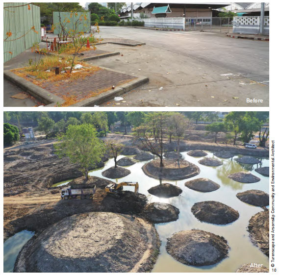
The site was densely occupied with single-story warehouses and hard pavements; except for four buildings, all on-site structures were planned to be removed that would leave a large amount of construction waste to be dealt with after demolition (Fig. 2).
Site survey showed that there were 865 trees on the site, including 91 species. These trees were mostly found along paths, and many Ficus benjamina have grown into the pavement with their robust root system. Therefore, it was a challenge for the design team to preserve the trees and make them a functional feature that is compatible with the plan of the site.
In addition to the challenges of the site itself, the budget for this project was extremely limited (ultimately, it was capped at USD 20/m2), and the project was required to be completed in just 18 months. An extra challenge was that the project was overseen by Royal Thai Army for a fast, efficient construction, but they did not have extensive experience managing landscape projects, so the design had to be easy-to-build. Besides, being costly and using a huge amount of irrigation water, the maintenance of Benjakitti Forest Park Phase I was unsatisfactory, so how to reduce the subsequent maintenance cost became another challenge to the design team.
3 Design Objectives and Strategies
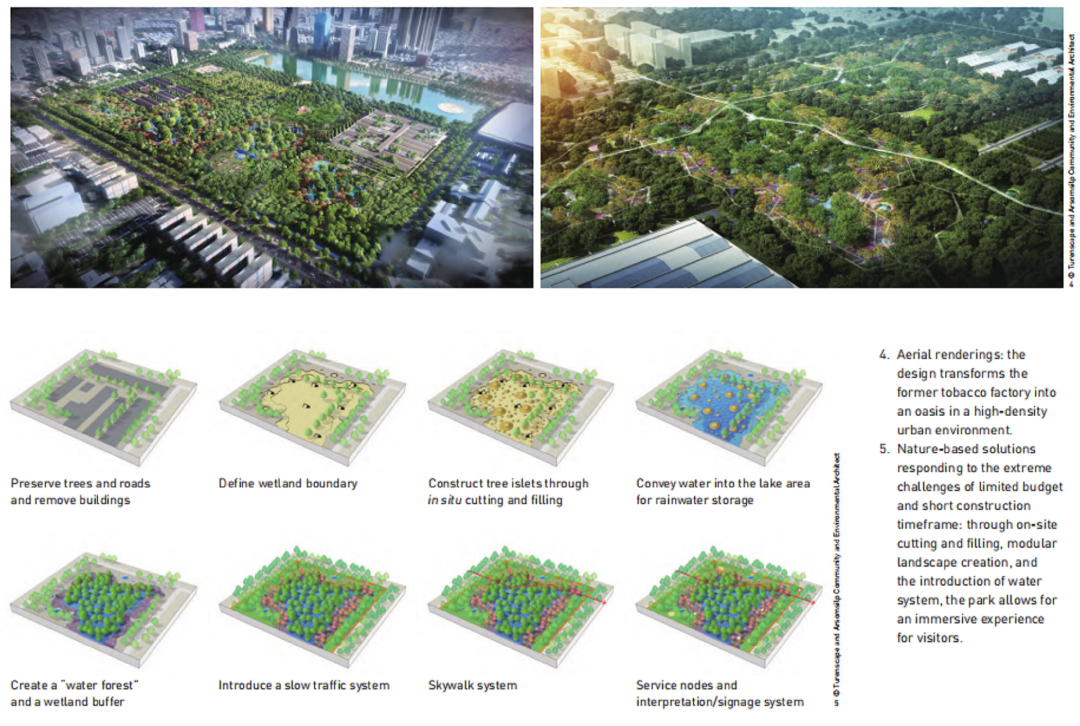
In addressing the multiple challenges of the site and its dense urban surroundings, the project was envisioned as a central park capable of providing holistic ecosystem services to the city (Figs. 3 ~ 5). To improve the site’s regulation services to adapt to the changing monsoon climate, the park is designed with a total rainwater retention and storage capacity of 187,500 m3, which allows the park to withstand 10-year rainfall events without draining to the municipal sewer system. To strengthen the site’s provisioning services, the park is designed to filter the polluted water from the poorest Class V to Class III. To enhance its supporting services, the design creates an ecosystem composed of forest, grass, and wetland that provides a variety of habitats for native species and wildlife. Also, to increase cultural services, the park is expected to offer badly needed large public recreational space for citizens’ daily recreational activities, as visitors as well. Three strategies guided the design to meet these objectives.
3.1 Creating Modular Porous Sponge Wetlands
Wetlands are important life-supporting systems [3] contributing to flood and drought prevention, soil and water conservation, maintenance of biodiversity, recreation and tourism, etc. [4][5] Highlighting an idea of “porosity,” the design creates a resilient, water-island interwoven sponge wetland system under landscape ecology principles [6].
Firstly, four lakes consisted of hundreds of tree islets (i.e., four constructed wetlands) were built through simple cutting and filling, and each lake was designed with two depths—a shallow, terraced shoreline and a deeper core area. After site investigation, the design team selected the three canopy moduli (6 m, 12 m, and 25 m) that were most frequently found among the existing trees as the island diameters in order to minimize construction impact on the existing vegetation; and then the trees were preserved in situ at the center of each island (Fig. 6). Standardized construction transformed the otherwise hard clay surface soil into a series of wet and spongy habitats (Fig. 7), where water acts as a medium to facilitate material and energy flows. The core areas not only serve as storage spaces, but also create diverse aquatic habitats with changing water levels [3].
The shallow, terraced shoreline is connected to the L-shaped linear purification wetland along the northern and western edges of the park, where the water from the canal is introduced and purified, with a daily purification capacity of 8,152 m3.
After pretreatment, polluted water enters the L-shaped surface flow wetland and subsurface flow wetland, flowing from east to west, from north to south, with the help of elevation difference. After a series of cleansing processes—including the aeration and the purification by emergent and submerged vegetation, microbial degradation, and biological predation—the concentration of pollutants (e.g., BOD, COD, TSS, heavy metal elements) would be largely reduced. The eutrophication substances such as nitrogen and phosphorus in the water can also be absorbed as fertilizers that help for the growth of wetland plants and agricultural crops on the site, forming a self-sufficient cycle.
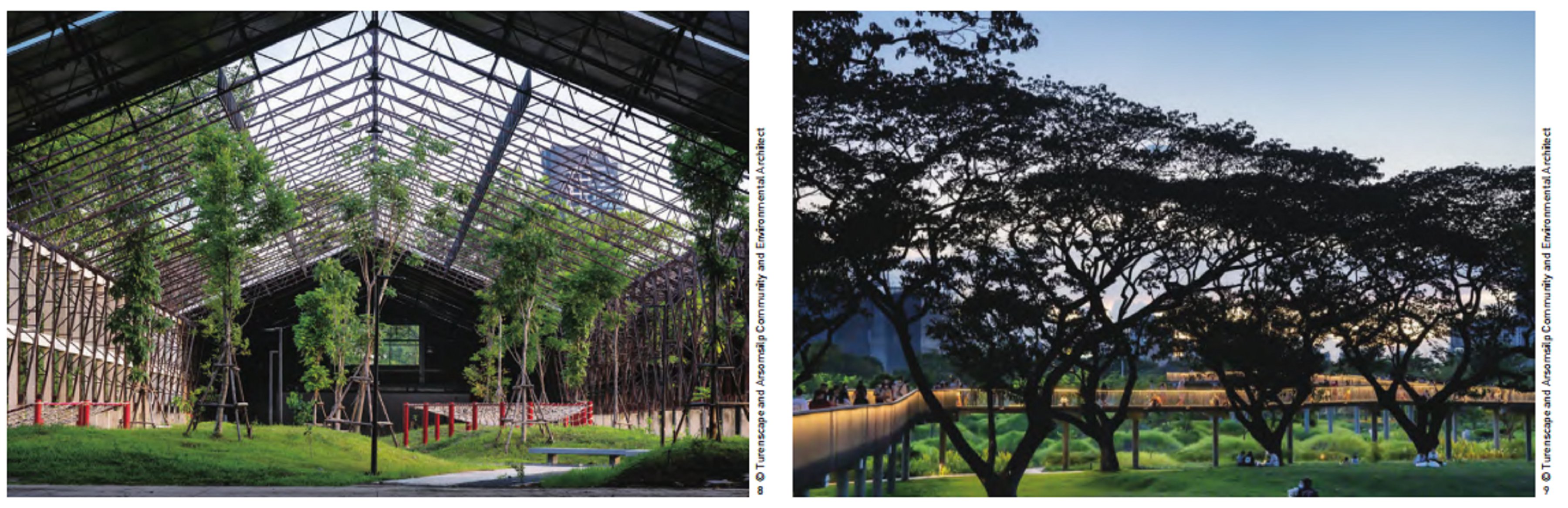
Secondly, some warehouses were redesigned with sports fields and eco-pallet islands (Fig. 8), creating a number of luxuriant “green buildings.”
3.2 Fostering a Low-Budget, Low-Maintenance “Messy Nature”
Considering the limitations in budget and construction period, all kinds of recycled materials on the site were integrated into the design of the park’s landscape: all existing main roads were remained as the skeleton of the new park circulation system; the existing trees and understory space were retained to the maximum extent (Fig. 9); and the concrete materials from the demolished structures were used to reinforce the foot and slope of tree islets or the park pavements.[2] This modular landscape can be easily executed with a single excavator and minimizes dependence on skilled labor (Fig. 10).
In addition, the planting design of the tree islets in this project applied seedlings of native shade tree species at the lowest cost: The modulated landform with diverse micro-environments was sown with seeds and planted with tree seedlings, creating a foundation for the subsequent evolution of a semi-natural plant community with low-maintenance (Fig. 11). After its completion, the park is expected to retain up to 200,000 m3 of storm water from the surrounding area during the monsoon season, allowing the native plant communities to establish themselves with minimal irrigation or maintenance needed during the dry season.
3.3 Improving Accessibility and Immersive Recreational Experience
To improve the accessibility of the park and enhance the connection between the park and the surrounding communities and green spaces, a skywalk runs through the tree canopies that ties together the entire park, which for decades was sliced through by major roads, and creates a unique experience amidst the tropical foliage while reducing the disturbance on wildlife (Fig. 12).
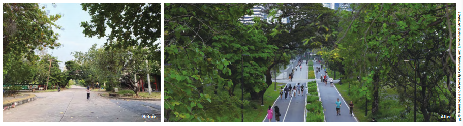
While the major roads were preserved and reused, a cut was made in the middle of each roadway to create a permeable bioswale and flower bed that separates a bicycle lane and pedestrian path, helping bring a more comfortable scale to what were originally wide roads designed for heavy truck traffic (Fig. 13). Multiple boardwalks were designed along the edge of the shallow wetlands that allow visitors to have immersive recreational experience of urban nature in the man-made wetlands (Fig. 14). A large lawn and an amphitheater in the core area of the park (Fig. 15), the rice field next to the converted museum (Fig. 16), and a large number of understory spaces were created to provide stages for varied recreational activities of Bangkok’s citizens and visitors.
4 After-Completion Performance and Reflection
Despite having been built on an extremely compressed timeframe, Benjakitti Forest Park has proven a great success. While much of Bangkok flooded last summer, the park and its immediate vicinity did not. The water-quality remediating wetland is performing well and produces enough water to keep the wetland alive through the dry season. A rich variety of birds and other wildlife has taken up residence in the park. The most striking achievement is that this naturally regenerative system is now the largest park in densely populated central Bangkok and attracts tens of thousands of visitors daily, who use it for a wide variety of activities, including jogging and cycling, family gatherings, school commencements, picnics, dates and wedding photographs. It has been celebrated extensively on social media as a new symbol of Thailand’s capital city (Fig. 15).
REFERENCES
