Guangzhou Sponge City Planning
Project Information
- Project Location:
- 中国 Guangzhou, Guangdong
- Project Scale:
- 7,434 Square Kilometers
- Design Time:
- July 2016
Project Profile
1. Project Statement
Guangzhou, the "southern gateway" of China and the political, economic, and cultural center of Guangdong Province, is situated in a transition zone between the Yuezhong low mountains and the Pearl River Delta. The city is characterized by heavy rainfall with uneven temporal and spatial distribution, dense water networks, heavy clay soils, and high groundwater levels. Under specific natural geographic conditions and rapid urbanization, Guangzhou faces frequent urban flooding and water-related issues, currently confronting severe water-related syndromes.
The plan addresses Guangzhou's severe water-related syndromes by focusing on the construction of water ecological infrastructure, abandoning the high-cost and high-maintenance grey "sponge projects." It creatively incorporates the ancient wisdom of production and living in the Pearl River Delta, combining three key strategies—absorption, deceleration, and adaptation—into the planning process. This forms a basic model of "source absorption and retention, process deceleration and energy dissipation, and terminal elastic adaptation," integrating contemporary ecological water management concepts with local water management wisdom to systematically solve problems of flooding, pollution, and water ecology.
With this core concept, the plan establishes the overall goals and indicator system for the construction of Guangzhou's sponge city, constructs the natural ecological spatial pattern of the city's sponge city at the municipal level, and develops the sponge city infrastructure system for the built-up area. It proposes zoning control and construction guidelines for the sponge city and provides specific plans and recommendations for the phased construction and implementation of the sponge city, ensuring coordination with related planning. The project planning covers 11 districts in Guangzhou, with a total area of 7,434 square kilometers and an urban built-up area of 1,093 square kilometers.
2. Objective and Challenge
High Flood Risk
Guangzhou's unique "dragon boat water" rainfall climate results in frequent heavy rainstorms during the early flood season, with concentrated rainfall periods. Under the influence of global climate change, extreme weather events are increasingly frequent, and the urban heat island effect is becoming more pronounced. The hardening of urban surfaces and the destruction of natural water retention and drainage systems lead to a sharp increase in urban stormwater runoff, significantly raising the risk of urban flooding. Due to its location at the estuary of the Pearl River Delta, Guangzhou experiences significant transboundary water flows. The central and southern regions of the city are mostly tidal or semi-tidal river sections, with water levels significantly affected by the Pearl River's flood tides. During heavy rains, the convergence of transboundary flood peaks, typhoon tides, and rapidly increasing upstream stormwater runoff raises flood peaks and prolongs high water levels, greatly increasing urban flood control and drainage pressures.
Severe Water Pollution
Influenced by multiple pollution sources such as stormwater runoff, domestic sewage, and industrial wastewater, Guangzhou's rivers and streams suffer from severe water pollution. According to the "Guidelines for Urban Black and Odorous Water Treatment," among the 35 reported black and odorous rivers in Guangzhou, 32 are classified as mildly polluted, and 3 as severely polluted, with a total length of about 293 kilometers. Some rivers still experience direct discharge of domestic and industrial wastewater, causing severe local pollution. Additionally, extensive impermeable surfaces and municipal drainage systems alter Guangzhou's natural hydrological characteristics, increasing surface runoff pollution loads. Agricultural non-point source pollution from excessive use of fertilizers and pesticides in upstream farming areas also significantly impacts river water quality.
Water Ecosystem Degradation and Reduced Ecosystem Services
Urban construction and land reclamation have led to the gradual reduction and degradation of Guangzhou's rich river systems and natural wetlands, compromising the integrity and continuity of water ecosystems. Some rivers in the central city have been artificially covered, cut off, or even filled due to urban infrastructure construction. Engineering measures targeting rivers have disrupted the material and energy cycles among water, soil, and biota, severely diminishing the rivers' self-purification capabilities and causing the loss of diverse riparian habitats essential for biological survival.
Tense Human-Water Relationship
Historically, Guangzhou's culture has been closely linked to water due to its unique geographical location, influencing the city's urban form and ways of living. However, urbanization has hardened rivers, impeding citizens' natural affinity for water activities. Unsustainable river pollution control efforts have resulted in worsening water quality and disorderly sewage discharge. The ecological resilience of rivers has weakened, vegetation communities struggle to survive, and wildlife has deserted the lifeless rivers, leading to the loss of ecological service value. Consequently, Guangzhou's water culture and landscapes have been damaged, and residents have shifted from living with water to living against it, exacerbating the tense human-water relationship due to flooding and pollution issues.
Goals
Water Ecology Goals:
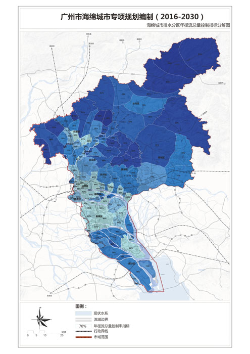
Control 70% of the annual runoff volume in Guangzhou, corresponding to a design rainfall of 25.80mm, and 60% in the central city, corresponding to a design rainfall of 18.90mm.
By 2020, restore at least 80% of the ecological shorelines. Achieve a water area ratio of 10.15% in the short term and over 11% in the long term.
Attain a forest coverage rate of 42.5% in the short term and control it at 44.15% or higher in the long term.
Water Safety Goals:
Ensure effective drainage and flood control in the central city to handle a 50-year storm event.
Achieve urban flood control standards: 200-year return period for the central city, 50-100 years for outer urban areas and key embankments, and 20-50 years for small and medium-sized rivers in key areas.
Water Environment Goals:
Achieve a water environment quality compliance rate of over 90% in the short term and 100% by 2030.
Reduce annual runoff pollution by at least 55% citywide and 50% in the central city by 2030, measured by the reduction in solid suspended solids (SS).
Water Resource Goals:
Achieve a wastewater reuse rate of at least 10% by 2020 and 15% by 2030, including ecological replenishment.
Utilize at least 3% of rainwater resources by 2030 and at least 1.5% by 2020.
Control the leakage rate of the public water supply network to below 10% after planning.
3. Design Strategy
Construct Ecological Infrastructure and Corridors to Improve Natural Ecological Spatial Patterns
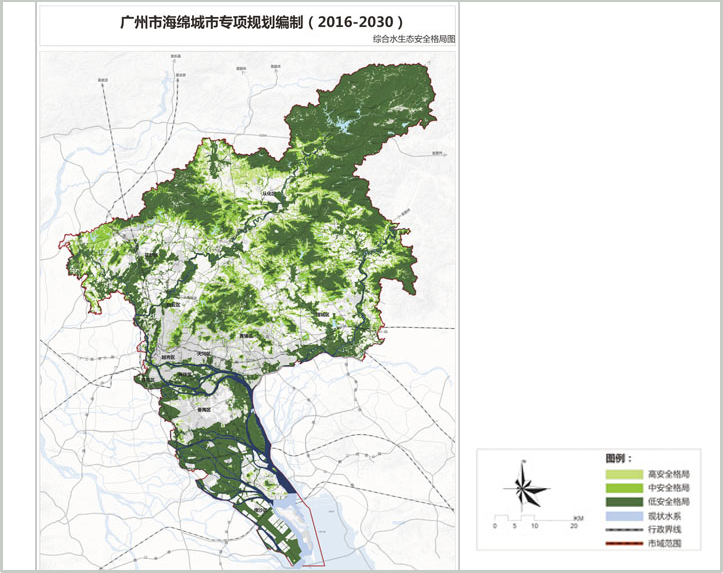
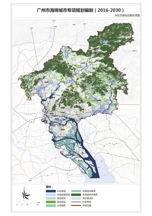
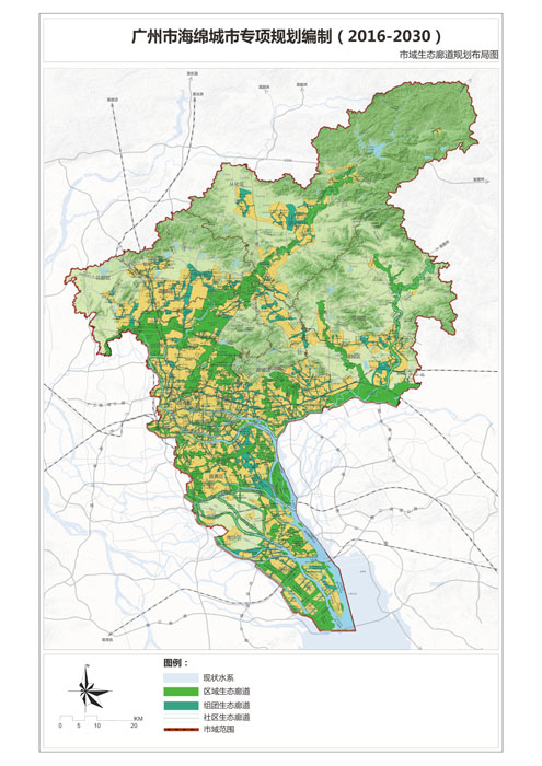
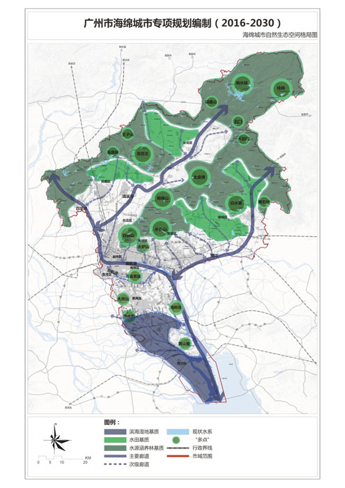
Identify seven key elements of the ecological security pattern: water source conservation forests, surface water protection areas, paddy systems, runoff corridors, retention ponds, ecological wetlands, and floodplains. Maintain spatial continuity and functional coordination to enhance the natural ecological pattern of the sponge city. Plan ecological corridors of different levels as the spatial foundation for ecological infrastructure, each serving various functions such as biological corridors, water and air cycles, urban isolation, and recreational spaces.
Combine Green Sponge Systems with Municipal Networks to Ensure Urban Water Safety
Integrate existing rivers, potential stormwater runoff corridors, various reservoirs, lakes, and wetlands into a green sponge system. Combine it with existing municipal settings to form a landscape model of source absorption and retention, process deceleration and energy dissipation, and terminal elastic adaptation, alleviating drainage system pressure and ensuring urban water safety.
Combine Natural Purification Systems with Sewage Interception Systems to Improve River Water Quality
Construct ecological facilities such as vegetative buffers and artificial wetlands to restore and enhance rivers' self-purification capabilities. Combine these with "grey" infrastructure like sewage pumping stations and sewage interception strategies to prevent water pollution.
Disperse Sponge Facilities to Control New Urban Surface Runoff
In new urban areas, aim to control annual runoff volume, using vertical runoff control and utilization according to site conditions. Disperse and treat rooftop and surface stormwater runoff on-site for buildings, roads, and plazas with appropriate conditions. Parks with suitable conditions should enhance the retention and purification functions of green spaces and water bodies.
Promote Dispersed Rainwater Utilization and Wastewater Reuse to Conserve Water Resources
In suitable areas, use facilities like water storage tanks and vertical greening to collect rainwater dispersedly and utilize it on-site for public green spaces, road plazas, production protection green spaces, and community green space irrigation. Develop wastewater reuse based on wastewater treatment plants, focusing on replenishing rivers or other ecological water uses and municipal miscellaneous water.
Preserve Lingnan Water Heritage and Water Management Wisdom to Promote Human-Water Harmony
Preserve Guangzhou's traditional water culture, protect water cultural heritage through sponge city construction, and enhance water landscapes, making water systems highlights of the city. Draw from and promote Guangzhou's traditional water management wisdom to rebuild harmonious human-water relationships.
4. Conclusion
The natural ecological spatial pattern of Guangzhou's sponge city features a layout of "two zones, three axes, four patches, eighteen corridors, multiple cores, and multiple networks."
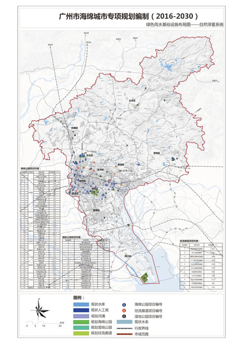
73 new sponge parks and wetland parks will be built, reducing drainage and flood control pressure in relevant drainage areas, and enhancing flood control and drainage standards with flexible adaptation to flood tides and sea level rise. Comprehensive measures will be adopted to improve drainage system design standards, with new areas and large-scale renovation areas constructed to a standard of 5-year return period, particularly important areas to a 10-year return period, and other areas to a 2-3 year return period.
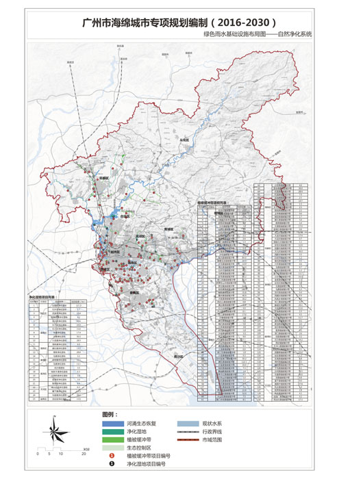
128 new vegetative buffers will be added to intercept vegetation and soil infiltration, slowing surface runoff velocity and removing some pollutants from runoff to reduce runoff pollution. 25 new artificial wetlands will be constructed to centrally purify black and odorous river water bodies in built-up areas. Planning of sewage networks, pumping stations, sewage treatment plants, and initial flow diversion facilities will combine green and grey infrastructure to jointly address black and odorous river issues. By the end of 2017, the black and odorous water bodies in urban built-up areas will be basically eliminated (35 rivers), and by the end of 2020, the goal of black and odorous water treatment will be achieved (152 rivers).
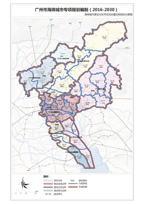
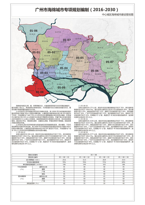
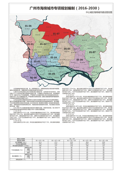
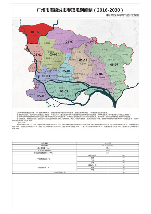
Based on controlling the annual runoff volume of new projects, focus areas for controlling runoff volume within each administrative district will be determined, divided into four categories: building complexes, roads and plazas, parks and green spaces, and ecological land, ensuring that each district meets the annual runoff volume control standards in combination with other construction areas.
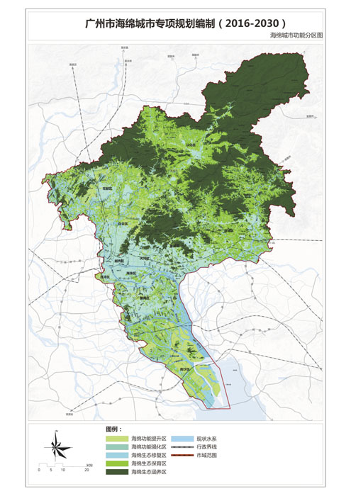
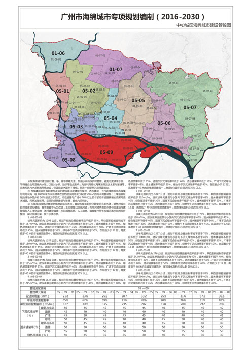
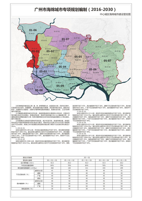
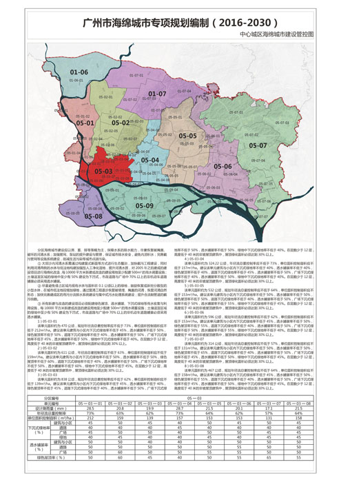
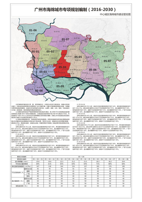
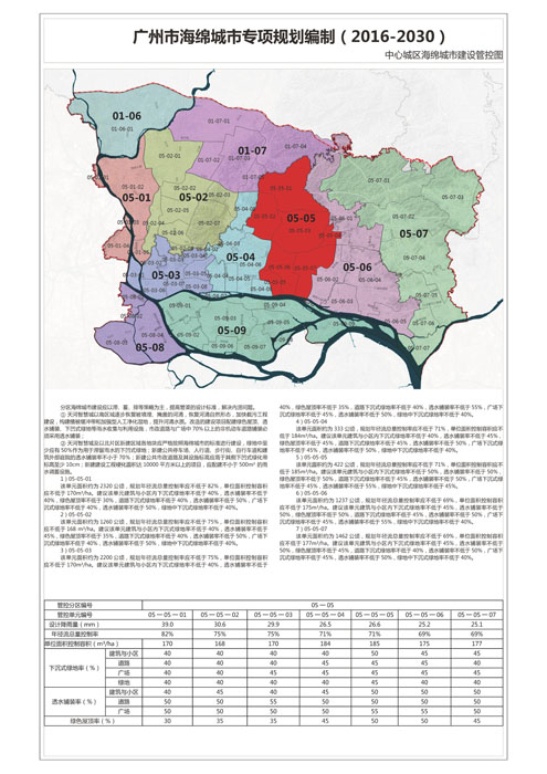
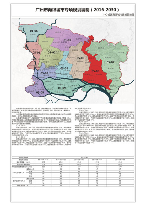
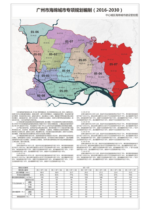
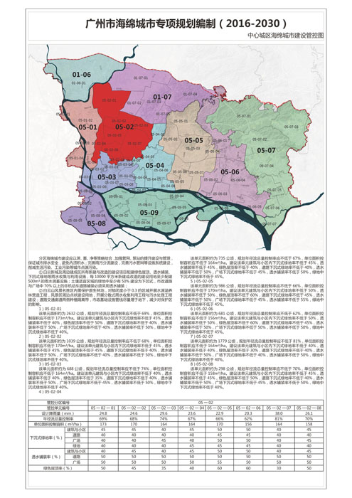
Based on natural watersheds, 8 construction watersheds, 35 construction zones, and 176 construction units are delineated, integrating the spatial pattern of Guangzhou's sponge system with the current land use and overall urban planning functions, basic farmland distribution, and ecological control lines. The evaluation divides the areas into five categories: sponge ecological conservation areas, sponge ecological protection areas, sponge ecological restoration areas, sponge function enhancement areas, and sponge function strengthening areas, highlighting corresponding construction guidelines.
A water cultural heritage corridor of 996 square kilometers will be established, focusing on heritage protection and ecological restoration within the corridor, strictly controlling construction, and enhancing the historical atmosphere of the water cultural heritage corridor through landscape improvement. Land use harmful to the corridor's development, such as high noise and high pollution, will be restricted, with recreation development as the main function, encouraging the construction of recreation facilities and projects closely related to the corridor's theme.
